Assessing Drought Conditions in Southern Baghdad (1988-2023) Using NDVI Anomaly and Its Impact on Soil and Vegetation


Research Article
Assessing Drought Conditions in Southern Baghdad (1988-2023) Using NDVI Anomaly and Its Impact on Soil and Vegetation
Auras Muhi Taha*, Ibrahim Ahmed Ibrahim, Hassanein Abduladeem, Mohammed Qais Yassen, Omaima Khalid Ahmed and Tabark Najim Abdul-Allah
Al-Karkh University of Science, Iraq.
Abstract | This study was conducted in southern Baghdad, the capital of Iraq, and the geographical coordinates of the study area consist of the circle of latitude 32°55’15.6989”N to 33°13’40.7824”N and longitude 44°14’26.9843”E to 44°34’02.4323”E. This study aims to evaluate drought levels for the period from 1988 to 2023 and their impact on soil uses and plant densities based on Landsat sensor data. The results showed that the very severe drought type dominated throughout the study period, followed by the severe drought type, while the moderate drought type was constantly decreasing with alternating drought periods, and he significant differences between drought level rates over 35 years. This study indicated a decrease in SAVI values over thirty-five years, i.e., the absence of a large portion of vegetation cover in favor of fallow soils. The regression coefficient also showed a substantial negative relationship between drought conditions and SAVI, where R2 = 0.855. The drought led to the transformation of 64.88% of the study area into urban areas, in addition to 24.28% of Barelands. Therefore, only 10.84% of the study area is still subject to continuous agricultural use. This study found that EVI values decreased, especially in recent years due to the effect of drought, as the regression coefficient reached R2. = 0.8534, with significant differences between EVI rates over thirty-five years confirming the deterioration of vegetation cover in the study area. It can be said that this region is moving towards accepting urban sprawl, whether planned or random. The results also showed the dominance of the low-density variety, as it reached approximately 53.46% of the area of the study area in the last decade, while the good-density and very good varieties were identified in agricultural areas where agricultural activity continues. However, it did not increase. Their percentages ranged between 12.15% and 11.34% over the past decade, and we believe that drought has a clear impact on this deterioration due to decreased rainfall and the use of poor-quality water for irrigation, in addition to increased concentrations of salts that continuously accumulate in the soil without leaching it.
Received | June 14, 2024; Accepted | August 13, 2024; Published | August 27, 2024
*Correspondence | Auras Muhi Taha, Al-Karkh University of Science, Iraq; Email: aurasssoil@kus.edu.iq
Citation | Taha, A.M., I.A. Ibrahim, H. Abduladeem, M.Q. Yassen, O.K. Ahmed and T.N. Abdul-Allah. 2024. Assessing drought conditions in southern Baghdad (1988-2023) using NDVI anomaly and its impact on soil and vegetation. Pakistan Journal of Agricultural Research, 37(3): 241-249.
DOI | https://dx.doi.org/10.17582/journal.pjar/2024/37.3.241.249
Keywords | Remote sensing, NDVI anomaly, Drought, Soil, Vegetation, Climate change
Copyright: 2024 by the authors. Licensee ResearchersLinks Ltd, England, UK.
This article is an open access article distributed under the terms and conditions of the Creative Commons Attribution (CC BY) license (https://creativecommons.org/licenses/by/4.0/).
Introduction
Drought is one of the most prominent manifestations of climate change, which is a natural and complex phenomenon that imposes major challenges on soil resources, agricultural patterns, water resources management, and ecosystem balance. Therefore, assessing drought conditions and understanding their effects on soil and vegetation is crucial for effective management of water resources and agricultural planning. and environmental sustainability (Mishra and Singh, 2010). Remote sensing data provide researchers with information that enriches the analysis of drought phenomena and provides realistic explanations related to the conditions of the place and for periods extending to tens of years, especially the Normalized Difference Vegetation Index (NDVI), through which it is possible to calculate agricultural drought (Nanzad et al., 2019), and Al-Waeli et al. (2020) that remote sensing data and spectral evidence provided a comprehensive picture of the state of soil and vegetation deterioration due to drought in the conditions of central Iraq. The Soil Modified Vegetation Index (SAVI) is a valuable tool for assessing plant health and monitoring drought stress in agricultural crops. By calculating soil brightness, SAVI provides a more accurate measure of vegetation strength, making it particularly useful in drought-prone areas and even improving irrigation strategies and predicting yield losses. SAVI also provides valuable insights into crop water status and their ability to withstand drought stress (Khozima et al., 2020). The Enhanced Vegetation Index (EVI) is also widely used to evaluate vegetation health and monitor drought stress in agricultural crops. It improves traditional vegetation indices by reducing atmospheric impacts and enhancing sensitivity to changes in vegetation, making it particularly valuable in drought-prone areas. Which indicates the effectiveness of the EVI in assessing and managing the effects of drought on crop productivity (Xie and Fei, 2021), and in monitoring the uses of soils in central Iraq and the effects of climate on them, Al-Waeli et al. (2024) emphasized the importance of using remote sensing data in understanding the nature Soil uses to evaluate the effects of drought on them over time, and it serves as an early warning tool to provide sustainable plans to confront climate change and mitigate its effects by following rational methods in managing soil and water resources in central Iraq. This study aims to use NDVI Anomaly to evaluate drought and its impact on soil use and Plant health status in southern Baghdad, the capital of Iraq, for the period from 1988 to 2023.
Materials and Methods
Study area
This study was conducted in southern Baghdad, the capital of Iraq, and the geographical coordinates of the study area consist of the circle of latitude 32°55’15.6989”N to 33°13’40.7824”N and longitude 44°14’26.9843”E to 44°34’02.4323”E, whereas total area roughly is 86351 ha. Field investigations were conducted based on the diversity of soil uses in this region, where 60 readings were taken with a GPS device with the UTM coordinate system, which were used as points to extract the values of the remote sensing data indicators of Landsat sensors for the years 1988 until 2023, as in Figure 1.
Landsat data processing
Landsat data acquisition from https://earthexplorer.usgs.gov/, The digital data of TM and ETM were processed as (1), While Equation 2 was used for the same purpose with regard to the treatment of the spectral bands of the Landsat sensor OLI_TIRS:
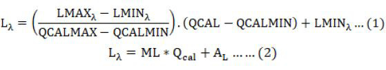
Where; Lλ = Spectral radiance at the sensor’s aperture, LMAXλ = Spectral radiance scaled to QCALMAX, LMINλ = Spectral radiance scaled to QCALMIN, QCALMAX = Maximum quantized calibrated pixel value (corresponding to LMAXλ) in DN = 255, QCALMIN = Minimum quantized calibrated pixel value (corresponding to LMINλ) in DN = 1,QCAL = Quantized calibrated pixel value in DN, ML = Radiance multiplicative scaling factor for the band (RADIANCE_MULT_BAND_n from the metadata), Qcal= Level 1 pixel value in DN, and AL= Radiance additive scaling factor for the band (RADIANCE_ADD_BAND_n from the metadata).
For all of the above, radiometric calibrations were performed according to (Al-Waeli et al., 2024) and atmospheric effects were removed using ENVI 5.6 software using FLAASH (fast line-of-sight analysis of atmospheric hypercube spectroscopic model) model according to (Wu et al., 2013).
Vegetation spectral indices
To evaluate drought and calculate the percentage of resulting coverage and the pattern of soil cover uses in the study area, the Normalized Difference Vegetation Index (NDVI) derived by Rouse et al. (1973) was adopted (Equation 3).
To evaluate the extent of agricultural soil degradation, either by abandoning agricultural activity in it or due to unplanned urban sprawl that is not based on the principles of sustainable management, the Soil-Adjusted Vegetation Index (SAVI) derived by Huete (1988) (Equation 4).
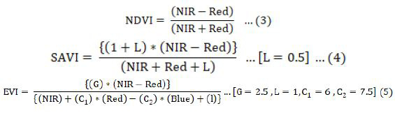
To evaluate the health status of the vegetation cover, the spectral index The Enhanced Vegetation Index (EVI) was adopted, which was derived by Huete et al. (1997) (Equation 5).
The NDVI anomaly estimation
The NDVI anomaly was adopted to estimate the drought in the study area for the years 1988-2023 (Nanzad et al., 2019) according to the following method.
(1) Because the growing season in central and southern Iraq extends clearly from the January until the middle of May and is often related to the growth of wheat leaves, the NDVI was calculated during this period by applying the following equation in in ENVI 5.6: (Equation 6)
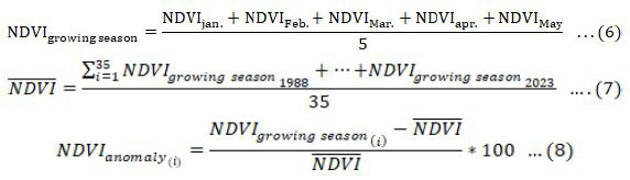
(2) The average of growing season for 35 years (1988-2023) was calculated by applying the following equation in in ENVI 5.6: (Equation 7)
(3) Estimating the drought for each year (i) was based on the deviation of an average for any year from the rate calculated in Equation ٧ by applying the following equation in in ENVI 5.6: (Equation 8)
(4) The severity of the drought was classified according to the levels shown in Table 1.
Table 1: Drought classes from NDVI anomaly values.
|
NDVI anomaly values (%) |
Description |
|
> 0% |
Normal (Non-drought) |
|
0 – (-10%) |
Mild drought |
|
(-10%)-(-25%) |
Moderate drought |
|
(-25%)-(-50%) |
Severe drought |
|
< -50% |
Very severe drought |
Classification of uses of soil cover
Based on our field investigations and their correspondence with the NDVI readings, the uses of soil cover in the study area were classified according to Table 2.
Table 2: Classification of uses of soil cover
|
NDVI |
Description |
|
<0.07 |
Urban |
|
0.07-0.20 |
Barelands |
|
> 0.20 |
Vegetation |
Calculating the percentage of vegetation cover (VgC%)
According to Al-Rifai and Al-Rubaie (2017), the vegetation coverage percentage (VgC%) was calculated, as implemented in the ENVI5.6, as in Equation 8. (Equation 9)

The percentage of vegetation cover (VgC%) was also classified according to Al-Rifaee and Al-Rubay (2017) as follows:
Statistical analysis
Numerical values were extracted from the remote sensing data using ArcGIS. Pro. v3.0.1, they were regression tested, all graphs were plotted in Microsoft Excel 365, and the least significant difference test was applied according to Al-Waeli (2020), using GenSTAT12.
Table 3: Classification of VgC%.
|
Scale |
Description |
|
0 – 20% |
Very low density |
|
21-40% |
Low density |
|
41-60% |
Medium density |
|
61-80% |
Good density |
|
81-100% |
Very density |
Cartography of study characteristics
To facilitate the presentation of the study characteristics maps, especially since they extend over 35 years, they were divided into four groups, as in Table 4.
Their averages were calculated using ArcGIS.Pro. v3.0.1.
Table 4: Group of years of study and characteristics.
|
Group |
Years |
|
G1 |
1988 – 1996 |
|
G2 |
1997 – 2005 |
|
G3 |
2006 – 2014 |
|
G4 |
2015 – 2023 |
Results and Discussion
Drought condition in the study area
Figure 3 shows the presence of three levels of drought in the study area over a period of 35 years: moderate drought, severe drought, and very severe drought. From Figure 4, it is clear that the very severe drought variety gained dominance throughout the study, followed by the severe drought variety, while the moderate drought variety was constantly declining with alternating periods of drought.
The state of drought can be understood as alternating through Figure 5, which shows the significant differences between drought rates over 35 years. It appears from Figure 5 that the years 2022, 1989, 2000, 2015, 2012, 2005, 2012, 2005 and 2007 are the driest in the study area and significantly exceeded the severity of their drought over the rest of the study years.
The phenomenon of drought in Mesopotamia is the result of the intersection of natural factors, most notably the low rainfall rates, with a clear neglect to adopt the concepts of sustainable management of water resources. According to the study of Albarakat et al. (2018), these factors are what contributed to the dominance of drought in Iraq in general and in its water wealth. Especially rivers, lakes and marshes directly. It also appears from the study of Al-Waeli et al. (2020) that central Iraq was affected by drought differently. He found that the year 2011 was the driest in this region for the period from 2004 to 2019. He emphasized that sustainable management has a role in reducing the effects of drought, especially in the agricultural environment. The means of adaptation to climate change are still slow and traditional, which delays alleviating these effects on the agricultural environment. In the study of Ahmed and Suleimany (2022), they emphasized the importance of taking the spatial dimension into account in studying the phenomenon of drought and the scientific methods associated with the place for managing water resources, which are the most affected by drought, in addition to the accompanying pressure on the agricultural environment due to soil deterioration and Remote sensing data represents the best means of identifying the areas most affected by drought, while providing indicators and data on the level of drought severity and its impact on the agricultural environment.
Evaluating the impact of drought on soil cover uses in study area
Figure 6 shows a clear degradation in soil cover over a period of thirty-five years in the study area. The decline in the values of the Soil-Adjusted Vegetation Index (SAVI) over time and the absence of a large portion of vegetation cover to account for the soil in this important agricultural region in Iraq. In the Middle East, through the emergence of civilization, it being the center of Mesopotamia is the most prominent example of climate change overcoming the agricultural community in this region and forcing it either to abandon the agricultural soil or to exploit it for unjustified urban sprawl in this important agricultural space, and this interpretation is reinforced by Figure 7, where The regression coefficient shows a highly significant negative relationship between drought condition and SAVI, where R2= 0.855. Figure 8 shows the fluctuation in SAVI rates over thirty-five years, where the years 2014, 2019, 2001, 2016, 2020, 2021, 2023, 2008 and 1998 achieved the lowest rates of degradation in soil use in the study area.
Figure 9 shows that the state of soil use in the study area has tended towards urban sprawl, which Figure 10 shows that in the last decade, 64.88% of the area of the study area was transformed into urban areas,
in addition to 24.28% Barelands, and therefore only 10.84% of the area The study area is still subject to continuous agricultural use, and the most prominent explanation is that years of drought and low amounts of water suitable for irrigation turned large areas into soils affected by salinity and uncultivable, which prompted their owners to sell them as residential lands.
These results are consistent with the findings of Al Waeli et al. (2020), where drought caused an increase in soil salinity and a decline in its quality, which negatively affected the possibility of its future use for agricultural purposes, and that human action and mismanagement did not enable farmers to confront climate changes represented by drought and lack of water. Suitability for irrigation of economic plants, causing the loss of the agricultural environment that is supposed to surround the basic and administratively planned urban areas. Ajjur and Al-Ghamdi (2021) point out that the absence of vegetation is one of the most prominent indicators of the impact of any region on climate change, and that failure to follow sustainable management of water resources in the Middle East and North Africa will exacerbate the negative impact of drought on human societies in this region, which It leads to famines and disasters due to economic degradation due to the loss of the agricultural environment, and this requires the adoption of sustainable plans to confront climate change. Hommad et al. (2023) indicated that climate changes due to decreased rainfall, high temperatures, and high evaporation rates are among the most prominent reasons why the agricultural environment in central Iraq is affected by high levels of drought, especially in the long dry season in Iraq, which leads to The agricultural environment in this important region will decline unless scientific measures are taken to confront drought and mitigate the impact of climate changes in this region.
Evaluating the impact of drought on vegetation in the study area
Figure 11 shows the decline in the values of the economic vulnerability index in recent years, and represents the state of deterioration in vegetation in the study area, despite its limitations. As we showed in Figures 9, 12 also shows the clear effect of drought on the values of this indicator, as the regression coefficient reached R2= 0.8534, with a highly significant negative relationship, although Figure 13 showed fluctuation in the values of the Economic Vulnerability Index over a period of thirty-five years, with significant differences between their rates confirming the deterioration of the vegetation cover in the study area, as it is noted that most years The periods in which the vegetation was exposed to the effects of devastating drought were in 2015, 2007, 1989, 2005, 1996, 1995, 1994, 2011 and 2017. Note that our field research did not observe a realistic practice of agriculture in agricultural areas, as most of the land is not cultivated and most of this vegetation is grasses and forest plants. It can be said that this region is moving towards accepting urban sprawl, whether planned or random.
Figure 14 shows the dominance of the low-density variety, as it reached in the last decade approximately 53.46% of the area of the study area, as in Figure 15, and that the good density and very good density varieties were identified in agricultural areas where agricultural activity continues. However, it did not increase. Their percentages ranged from 12.15% and 11.34% during the last decade, as shown in the figure. We believe that drought has a clear impact on this deterioration due to decreased rainfall and the use of poor-quality water for irrigation, along with increased concentrations of salts that continuously accumulate in the soil without leaching it.
Al-Rifaee and Al-Rubay (2017) confirm that the quality of water used for irrigation has a clear impact on the state of vegetation in the conditions of central and southern Iraq. The poor suitability of irrigation water causes weak plant growth and poor productivity, and it also contributes to the salinization of the soil and its gradual transformation. To barren salt deserts that are not suitable for agriculture, and the climate changes that force farmers to resort to irrigation with unknown quality water sources clearly contribute to a decline in the productivity of the land and leaving it unsuitable for agricultural use. Ajjur and Al-Ghamdi (2021) also showed the possibility of adapting to climate changes and adapting to drought by growing drought-resistant plants and moving towards agroforestry in the conditions of the Middle East and North Africa, which are clearly affected by drought and whose agricultural lands gradually turn into barren lands. Hommad et al. (2023) find it necessary to evaluate the suitability of water for irrigation before using it, because irrigation with unreliable sources exacerbates the problems resulting from climate change, most notably drought, which gradually destroys vegetation and turns agricultural areas into barren lands, causing many environmental problems for the urban areas adjacent to them.
Conclusions and Recommendations
From this study, we point out the importance of relying on remote sensing data in understanding the impact of climate change, especially drought, on the agricultural environment. SAVI presented in this study the impact of drought in reducing vegetation cover and increasing fallow soil, which has become coveted in the last decade due to unstudied urban expansion, as well as the decrease in EVI values are especially high in recent years, indicating a deterioration of vegetation. Regression analysis showed a significant negative relationship between drought conditions and EVI values, which supports the negative impact of drought on vegetation in southern Baghdad, the capital of Iraq. Southern Baghdad witnessed mostly severe and very severe droughts during a period of 35 years. This indicates that the region has been significantly affected by long periods of water scarcity and low rainfall. The dominance of low-density plant varieties in the study area indicates low quality and density of vegetation. This decline may be linked to the harmful effects of drought, including water stress, limited resources for plant growth, and general deterioration of environmental conditions necessary to maintain healthy and diverse plant communities. Therefore, southern Baghdad is witnessing urban sprawl that indicates the unplanned or uncontrolled expansion of urban areas into rural areas due to drought. The movement toward urbanization observed in the region may have implications for land use planning, environmental conservation and sustainable development.
Novelty Statement
This study, which specifically addressed the issue of drought in Iraq, south of Baghdad, is of great importance because this region is considered an important food basket for the country and its exposure to drought to this extent is considered a dangerous human disaster that requires rapid intervention to stop it.
Author’s Contribution
Auras Muhi Taha: Conceptualization, data curation, formal analysis, funding acquisition, investigation, methodology, resources, software, supervision, validation, visualization, writing original draft, writing - review and editing, project administration.
Ibrahim Ahmed Ibrahim: Investigation, resources, software, writing review and editing
Hassanein Abduladeem, Mohammed Qais Yassen, Omaima Khalid Ahmed and Tabark Najim Abdul-Allah: Validation.
Conflict of interest
The authors have declared no conflict of interest.
References
Ahmed, Z.A. and J.M.S. Suleimany. 2022. Drought vulnerability modeling over Mandawa watershed, northern Iraq, using GIS-AHP techniques. Polytech. J., 12(2): 136–147. https://doi.org/10.25156/ptj.v12n2y2022.pp136-147
Ajjur, S.B. and S.G. Al-Ghamdi. 2021. Evapotranspiration and water availability response to climate change in the Middle East and North Africa. Clim. Change, 166(28): 1–18. https://doi.org/10.1007/s10584-021-03122-z
Al-Waeli, A.M. Taha, F.W. Al-Azawi and H.M. Hamid. 2024. Evaluation of the sensitivity of Al-Husseiniya soils in Karbala to erosion using Landsat sensors. Environ. Challenges, 14. https://doi.org/10.1016/j.envc.2024.100857
Al-Waeli, A.M.T., S.M. Taha and S.S. Mahmood. 2020. Evaluation of drought impact on agricultural status for some Waist’s soil using geomatic techniques. Plant Arch., 20(2): 554-565.
Al-Waeli, A.M.T., 2020. Assessment of soil sensitivity for physical degradation in Abi-Garaq by geomatics techniques. Int. J. Agric. Stat. Sci., 16 (Supplement 1): 1865–1873.
Albarakat, R., V. Lakshmi and C.J. Tucker. 2018. Using satellite remote sensing to study the impact of climate and anthropogenic changes in the Mesopotamian Marshlands, Iraq. Remote Sens., 10(1542): 1–22. https://doi.org/10.3390/rs10101524
Al-Rifaee, M.K.I. and A.A.M. Al-Rubay. 2017. Effect of adding irrigation water quality index to MEDALUS model in environmental sensitivity to desertification in Sheikh Saad project L, ands Wasit Governorate. Iraqi J. Agric. Res., 22(1): 101–116.
Hommad, A.H.I., N.A. Al-Ansari, A. Al-Obaidy, W.K. Obied, R.N. Abdul-Ghni, S.A. Abed. 2023. Evaluating water scarcity indices for cultivation region in Sadat Al-Hindya, Babylon, Iraq: A case study. Engineering, 15: 647–662. https://doi.org/10.4236/eng.2023.1510045
Huete, A.R., 1988. A soil adjusted vegetation index (SAVI). Remote Sens. Environ., 25: 295–309. https://doi.org/10.1016/0034-4257(88)90106-X
Huete, A.R., H.Q. Liu, K. Botchily and W. Leeuwen. 1997. A comparison of vegetation indices global set of TM images for EOS-MODIS. Remote Sens. Environ., 59: 440–451. https://doi.org/10.1016/S0034-4257(96)00112-5
Khozima, M.Y., S. Asika, T. Yıldırım, A.M. Abdelmalik and A.J. Khashoggi. 2020. Agricultural drought monitoring using surface temperature and vegetation indices from satellite images. Ege Univ. Ziraat Fak. Derg. Ozel Sayı, pp. 151-160. https://doi.org/10.20289/zfdergi.836217
Mishra, A.K. and V.P. Singh. 2010. A review of drought concepts. J. Hydrol., 391(1-2): 202-216. https://doi.org/10.1016/j.jhydrol.2010.07.012
Nanzad, L., J. Zhang, B. Tuvdendorj, M. Nabil, S. Zhang and Y. Bai. 2019. NDVI anomaly for drought monitoring and its correlation with climate factors over Mongolia from 2000 to 2016. J. Arid Environ., 164: 69–77. https://doi.org/10.1016/j.jaridenv.2019.01.019
Rouse, J.W., R.H. Hass, J.A. Schell and D.W. Deering. 1973. Monitoring vegetation systems in the great plains with ERTS. In: Proceedings of the third ERTS-1 Symposium, NASA SP-351, 1: 309–317.
Wu, W., A. Platonov, F. Ziadat and A.S. Mhaimeed. 2013. Quantifying of the spatial distribution of salt-affected land central and southern Iraq. ICARDA. Iraq Salinity Project. Tech. Rep., 1: 1–25.
Xie and H.F. Fei. 2021. Deriving drought indices from MODIS vegetation indices (NDVI/EVI) and Land Surface Temperature (LST): Is data reconstruction necessary? Int. J. Appl. Earth Observ. Geoinf., 101: 102352. https://doi.org/10.1016/j.jag.2021.102352
To share on other social networks, click on any share button. What are these?