Agricultural Water Poverty Index: A Tool for Agricultural Water Resources Management in District Dir Lower, Khyber Pakhtunkhwa, Pakistan


Research Article
Agricultural Water Poverty Index: A Tool for Agricultural Water Resources Management in District Dir Lower, Khyber Pakhtunkhwa, Pakistan
Khalid Hussain, Muhammad Jamal Nasir*, Anwar Saeed Khan and Hafiz Ullah Khan
Department of Geography and Geomatics, University of Peshawar, Peshawar, 2500, Pakistan
Abstract | Water resources play a key role in human health, human needs, well-being, and development. Despite its prominent importance, water resources are highly stressed in different parts of the globe, particularly the developing nations. High competition for water resources with an increase in population and their poor management led to water scarcity that ultimately badly threatened global food security. This study aims to identify the degree of agricultural water poverty and to propose a map of AWP in district Dir Lower, using GIS. The data of five major components of AWPI; resources, usage, capacity, access, and environment, and their sub-components were collected through a questionnaire survey including questions about all these parameters. In all 35 union councils (UCs) of the study area, 5 respondents from each union council were selected randomly and priority was given to long-time farmers. The data collected were tabulated and the maximum (Xmax) and minimum (Xmin) values for each sub-component of each major AWPI component were determined and, subsequently, the WPI was computed by combining all the sub-components of the five major components. UCs; Balambat, Chakdara, Kambat, Kotkai, Koto, Kotigram, Lajbok, Lal Qilla, and Ouch recorded very high agricultural water poverty with an overall AWPI rank of 5 each. The reason behind this low AWPI is the lack of water management knowledge, poor access to water resources, poor coping strategies, and lack of fertilizers and pesticides. On the other hand, union councils Hayaseri and Tormang were found with very low agricultural water poverty with an Overall AWPI Rank of 1 each. Out of 35 UCs of Dir Lower, 12 have moderate, 11 have high, 9 have very high, 1 has low and 2 UCs have very low AWPI. This study anticipates strengthening the concepts of agricultural water poverty to effectively alleviate the problem and achieve balanced regional development. The results and findings may prove useful to policymakers and implementing agencies.
Received | May 21, 2024; Accepted | July 13, 2024; Published | September 17, 2024
*Correspondence | Muhammad Jamal Nasir, Department of Geography and Geomatics, University of Peshawar, Peshawar, 2500, Pakistan; Email: drjamal@uop.edu.pk, drjamal.geog@gmail.com
Citation | Hussain. K., M.J. Nasir, A.S. Khan and H.U. Khan. 2024. Agricultural water poverty index: A tool for agricultural water resources management in District Dir Lower, Khyber Pakhtunkhwa, Pakistan.. Sarhad Journal of Agriculture, 40(3): 1081-1101.
DOI | https://dx.doi.org/10.17582/journal.sja/2024/40.3.1081.1101
Keywords | AWPI, Water Resources, Use, Capacity, Access, Environment
Copyright: 2024 by the authors. Licensee ResearchersLinks Ltd, England, UK.
This article is an open access article distributed under the terms and conditions of the Creative Commons Attribution (CC BY) license (https://creativecommons.org/licenses/by/4.0/).
Introduction
Water is used for agriculture at the largest scale out of other uses that have been significantly threatened by population growth, socioeconomic development, and climate change (Rosa, 2022). Excessive shortage of water for agriculture is predicted to badly affect crop yields ultimately threatening food security specifically the poor nations of the World (Pastor et al., 2019). Agricultural water shortage is a key issue and its management is a prominent topic around the globe particularly the water-scarce community (Richter et al., 2017; Shen et al., 2022; Alotaibi et al., 2023). Agricultural water scarcity appears to be caused by either natural or man-made factors (Mehta, 2001; Noemdoe et al., 2006). Agricultural Water Poverty Index (AWPI) has been used for the first time by (Sullivan, 2002) for hydrological modeling. AWPI is frequently used to assess the water poverty and status of irrigation water in the agriculture sector (Lilienfeld & Asmild, 2007).
In the view of El-Gafy (2018), AWPI integrates the physical availability of water, access to water, the capacity of people of water management to ensure access to water, water use for various purposes, and environmental drivers that affect water supply. According to Hemmati et al. (2016), AWPI deals with the human’s economic and social abilities for efficient usage of water for environmental and productive purposes. The primary function of AWPI is to demonstrate that agricultural water poverty is the most important factor influencing the development of agriculture in a region. It might also be used to compare regions depending on the state of their agricultural water resources, enabling improved agricultural water management planning (Forouzani & Karami, 2011).
Each of the AWPI components is given weight for the calculation of the final number yielding the index (Zarafshani & Saadvandi, 2017). Similarly, Forouzani et al. (2013) proposed AWPI to highlight the scarcity of water in Marvadasht County of Southern Iran by using resources, access, capacity, use, and environment as basic parameters with indicators. Finally, Forouzani et al. (2013) yielded AWPI by using the modified version of WPI proposed by Lawrence et al. (2002). Measuring water poverty comprehensively provides a holistic view of the linkages between water, agriculture, and poverty, which can inform policy decisions and resource allocation (Hussain et al., 2022). The Agriculture Water Poverty Index is a composite index that combines various parameters related to agriculture, water, and poverty. The framework for the Agricultural Water Poverty Index used in the current study has a total of five components and seventeen indicators. Table 1. shows the five components of AWPI and its seventeen indicators (sub-components) (Sullivan, 2002; Nihila et al., 2012). Several researchers used this index to compute the AWPI for various parts of the World (van der Vyver, 2013; Zarafshani & Saadvandi, 2017; Shadeed et al., 2020; Hawrami and Shareef, 2020; Hussain et al., 2022 ). Lawrence et al. (2002) and Sullivan et al. (2006) designed AWPI includes five parameters; resources (R), access (A), capacity (C), use (U), and environment (E) to assist the government and donor agencies to step forward for interventions in water sector at national and community level. The water resources availability measures the physical access to water resources in a given area, including the availability of surface water, groundwater, and rainfall. This component reflects the higher the amount of the water resources, the better the water situation in an area. Access represents the human accessibility to water to take the safe source of water for household and other requirements. In the context of agriculture, it refers the adequate accessibility to water for plant growth. The capacity is the set of socioeconomic factors that show the farmers effectiveness to manage water resources. Use represents the actual amount of water that is being used achieved from the system. It includes water uses for agricultural, domestic and industrial purposes. The environment refers the factors that have impacts on supply of water. This parameter not only include on water quality but also covers variables like fertilizers and pesticides (Giné et al., 2013).
Precipitation in the study district Dir Lower is highly variable. Both rain-fed and irrigated agriculture are practiced, however, irrigated agriculture is confined to a small area along the banks of perennial streams. Rain-fed agriculture is entirely dependent on highly variable rainfall over time and space. In addition, the yearly precipitation in Dir Lower is not only very unpredictable but also inadequate for agricultural crop water requirements, resulting in frequent crop failure. The farming communities have limited resources due to traditional agriculture practices and consequently face Agricultural Water Poverty. Therefore, the current study is aimed to assess the agricultural water poverty in the study area.
Materials and Methods
Study Area
This study is conducted in Dir Lower, one of the mountainous districts of Khyber Pakhtunkhwa, Pakistan. Dir Lower is located in the northern part of Pakistan. It lies between 34º 37’ 35” to 35º 03’ 05”
north latitudes and 71º 32’ 35” to 72º 08’ 03” east longitudes (Ullah et al., 2014). In the north, it is bounded by Upper Dir, district Bajaur, and Afghanistan on the west, district Malakand on the south, and east by district Swat (Figure 1). The study area spreads over an area of 1734.61 km2 (digitized through GIS 10.8) with an altitude ranging from 581 meters to 3291 meters. The average annual temperature and rainfall have been recorded at 16 °C and 1186 mm respectively (Sarwar et al., 2021).
Data Collection
The agricultural water poverty index (AWPI) mainly consists of five major components namely; resources, usage, capacity, access, and environment (van der Vyver, 2013). Table 1. shows AWPI components and sub-components that were used to compute the AWPI. Though several indicators have been proposed for evaluating AWP at global, regional, or local levels, the one proposed by AWPI has been highly acknowledged by researchers for measuring AWP at farm as well as community levels. A total of 17 sub-components were utilized to compute the AWP in the study area (Table 1). The resource sub-component R1-Runoff Potential was computed from land use land cover (LULC) and hydrological soil group (HSG). The Sentinel-2 image of 2022 with a 10-meter spatial resolution was acquired from the Copernicus Open Access Hub website. Utilizing ArcMap 10.8 Spatial Analyst, the image was classified into several LULC classes using the Maximum likelihood classification algorithm. The HSG data were downloaded from https://daac.ornl.gov/about/. The LULC and HSG data were then used to calculate the union council-wise runoff potentiality of the study area. For calculation of rainfall potentiality, the rainfall data of the study area and surroundings were acquired from the Pakistan Meteorological Department, Regional Office Peshawar. The acquired data were interpolated in ArcMap and subsequently, union council-wise rainfall potentiality was computed. The groundwater table (GWT) was measured with the help of a string and a small weight (a metal nut) attached to its one
Table 1. AWPI Components and Sub-components.
|
Components |
AWP indicators |
|
|
Resources |
R1 |
Runoff potential |
|
R2 |
Rain potential |
|
|
R3 |
Water table depth |
|
|
Access |
A1 |
Distance between farm and water source |
|
A2 |
Ratio of uncultivated land because of water scarcity to total irrigated lands of farmer |
|
|
A3 |
Number of conflicts reported over water usage creating from farmer |
|
|
A4 |
%age of the agricultural land having access to canal or river for irrigation |
|
|
Capacity |
C1 |
Educational level |
|
C2 |
Water management knowledge |
|
|
C3 |
Being an innovative farmer
|
|
|
Use |
U1 |
Crop yield |
|
U2 |
Compliance with planting dates to take advantage of soil moisture |
|
|
U3 |
Coping strategies towards water scarcity |
|
|
U4 |
Farming of water resist crops varieties |
|
|
Environment |
E1 |
Water quality |
|
E2 |
Consumption of fertilizer (kg) per hectare of cultivated land |
|
|
E3 |
Use of pesticide (liter) per hectare of cultivated land |
|
Source: (Sullivan, 2002; Nihila et al., 2012).
end. When the weight was dropped into the well, the tension on the string relaxed slightly, and a wave appeared in the water, indicating that the weight had indeed struck the water. After that, a measuring tape was used to determine how long the string was. However, in the majority of situations, the locals informed us about the GWT depth.
The data regarding the rest of the sub-components were collected through a questionnaire survey including questions about all these components and sub-components. A union council-wise survey was conducted and, 05 respondents were surveyed from each union council (UC). The respondents were selected randomly and priority was given to long-term farmers.
Computing and Mapping of AWPI
The AWPI components and sub-components were divided into two groups. Group 1 includes all those parameters which are directly proportional to agricultural water poverty. The higher the value of these sub-components the higher the AWP. Group 2 includes all those sub-components which are inversely proportional to agricultural water poverty. The higher the value of those sub-components the lower the AWP. The data of the chosen sub-components for each union council was expressed in various units. Therefore, they were standardized through equations 1 and 2 (Nasir et al. (2020); Nasir et al. (2021). The standardization and ranking of group 1 was carried out using Eq.1, while group 2 was standardized by Eq. 2.
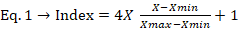
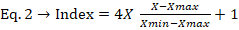
Where the index is Resources (R), Use (U), Capacity (C), Access (A), and Environment (E), X= actual value of each AWP parameter, Xmax= Highest value of the sub-component, Xmin= Lowest value of sub-component
This resulted in a standardized factors score at a scale of 1 to 5, demonstrating the level of AWP for each sub-component in comparison to the identical sub-component in the other union councils. Rank 1 and rank 5 show very low and very high AWP respectively. For group one sub-components higher value indicates a very high AWP and a low value shows
a very low AWP. However, in the case of group two sub-components, a high value indicates very low AWP and a low value indicates very low AWP. The AWPI was calculated by combining the sub-component’s ranking score for each UC and subsequently divided into five AWP classes: Very low AWP, low AWP, moderate AWP, high AWP, and very high AWP by equal interval classification method in ArcMap 10.8. The UC-specific AWPI spatial distribution map was then computed. Equation 3 shows the WPI overall value for a specified UC as reported by Lawrence et al. (2002) and Nihila et al. (2012). The methodology is summarized in the flow chart depicted in Figure 2.

Where AWPI is the calculated Agriculture Water Poverty Index, RR rank of component Resource (R1+R2+R3), RA rank of component Access (A1+A2+A3+A4), RU rank of component Use (U1+U2+U3+U4), RC rank of component Capacity (C1+C2+C3) and RE rank of component Environment (E2+E3).
Results and Discussion
Resources
The “resource” component of AWPI is comprised of runoff potential, rain potential, and water table depth. Runoff potential refers to the likelihood of rainwater or snowmelt running off the land surface rather than infiltrating. It is influenced by various factors such as LULC, slope, topography, soil type and texture, vegetation cover, and rainfall intensity.
Rainfall potential is often used to describe the likelihood of precipitation occurring in a particular area. Rainfall potential can be estimated using various meteorological models and data sources, such as satellite observations, weather radar, and ground-based measurements. The groundwater table depth (GWTD) refers to the distance between the land surface and the level below which the soil and rock are saturated with water. The depth of the water table can vary depend ing on factors such as topography, soil type, climate, vegetation cover, and human activities. They can also be influenced by human activities such as groundwat-er extraction, land-use changes, and construction
Table 2. District Dir Lower Resources.
|
UC |
R1 |
R2 |
R3 |
Overall Rank |
AWPI Rank |
AWPI |
|||
|
GWT in feet |
Rank |
Runoff Potential |
Rank |
Rainfall Potential |
Rank |
||||
|
Bishgram |
65 |
2 |
85.2 |
3 |
759.98 |
1 |
6 |
1 |
V. Low AWP |
|
Timergara |
15 |
1 |
87.16 |
1 |
149.29 |
4 |
6 |
1 |
|
|
Khal |
55 |
2 |
87.16 |
1 |
184.15 |
4 |
7 |
1 |
|
|
Khazana |
30 |
1 |
87.16 |
1 |
81.33 |
5 |
7 |
1 |
|
|
Tormang |
90 |
2 |
87.16 |
1 |
172.94 |
4 |
7 |
1 |
|
|
Chakdara |
50 |
2 |
87.16 |
1 |
78.01 |
5 |
8 |
2 |
Low AWP |
|
Khadagzai |
40 |
1 |
85.35 |
2 |
140.13 |
5 |
8 |
2 |
|
|
Munjai |
50 |
2 |
86.68 |
1 |
83.31 |
5 |
8 |
2 |
|
|
Samar Bagh |
85 |
2 |
82.5 |
1 |
110.4 |
5 |
8 |
2 |
|
|
Bagh Dushkhel |
85 |
2 |
84.72 |
3 |
167.73 |
4 |
9 |
2 |
|
|
Bandagai |
100 |
3 |
81.5 |
1 |
129.04 |
5 |
9 |
2 |
|
|
Munda |
38 |
1 |
83.92 |
3 |
119.82 |
5 |
9 |
2 |
|
|
Noora Khel |
95 |
3 |
83.71 |
1 |
131.13 |
5 |
9 |
2 |
|
|
Shahi Khel |
51 |
2 |
85.35 |
3 |
157.49 |
4 |
9 |
2 |
|
|
Badwan |
70 |
2 |
86.5 |
3 |
55.19 |
5 |
10 |
3 |
Moderate AWP |
|
Khungi |
65 |
2 |
86.16 |
3 |
88.6 |
5 |
10 |
3 |
|
|
Koto |
50 |
2 |
83.72 |
3 |
69.91 |
5 |
10 |
3 |
|
|
Lal Qilla |
90 |
2 |
82.81 |
4 |
157.98 |
4 |
10 |
3 |
|
|
Main Kalai |
90 |
2 |
84.61 |
3 |
97.55 |
5 |
10 |
3 |
|
|
Maskini |
170 |
4 |
83.88 |
1 |
111.41 |
5 |
10 |
3 |
|
|
Mayar |
95 |
3 |
84.61 |
3 |
166.89 |
4 |
10 |
3 |
|
|
Drangal |
135 |
3 |
83.72 |
3 |
98.39 |
5 |
11 |
4 |
High AWP |
|
Gall |
45 |
2 |
82.81 |
4 |
88.49 |
5 |
11 |
4 |
|
|
Kambat |
115 |
3 |
83.92 |
3 |
129.35 |
5 |
11 |
4 |
|
|
Khanpur |
115 |
3 |
83.92 |
3 |
108.72 |
5 |
11 |
4 |
|
|
Kotigram |
110 |
3 |
83.92 |
3 |
95.9 |
5 |
11 |
4 |
|
|
Kotkay |
135 |
3 |
84.6 |
3 |
75.94 |
5 |
11 |
4 |
|
|
Ouch |
130 |
3 |
83.92 |
3 |
70.3 |
5 |
11 |
4 |
|
|
Zaimdara |
70 |
2 |
82.81 |
4 |
67.26 |
5 |
11 |
4 |
|
|
Asbanr |
120 |
3 |
82.81 |
4 |
103.62 |
5 |
12 |
5 |
V. High AWP |
|
Hayaseri |
45 |
2 |
81.5 |
5 |
106.18 |
5 |
12 |
5 |
|
|
Rabat |
170 |
4 |
82.81 |
4 |
170.62 |
4 |
12 |
5 |
|
|
Tazagram |
155 |
4 |
83.75 |
3 |
92.52 |
5 |
12 |
5 |
|
|
Balambat |
220 |
5 |
84.6 |
3 |
64.84 |
5 |
13 |
5 |
|
|
Lajbok |
200 |
5 |
82.51 |
4 |
74.1 |
5 |
14 |
5 |
|
of drainage systems.
The UC-level “Resource sub-component” situation is depicted in Table 2. The analysis reveals that the GWTD varies from 15 feet to 220 feet in the study area. This variation is attributed to the undulating topography of the study area. The lowest groundwater table depth (15 feet) with a standardized score of 1 was reported from UC Timergara, while, the deepest GWTD (220 feet) with a score of 5 was reported from UC Balambat. The deepest GWT is due to the relatively low rainfall potentiality and steep topography. Similarly, the runoff potentiality of the study area is ranging from 81.5 to 87.16. The lowest runoff potentiality was computed for UC Bandagai and Hayaseri while the highest was calculated for UCs Khazana, Khall, Chakdara, Timergara, and Tormang. The rainfall potentiality varies from 55.18mm to 759.98mm. The lowest rainfall potentiality was computed for UC Badwan and the highest for UC Bishgram. Figure 3A. highlights the overall score of the “resource” sub-components (R1, R2, and R3) of AWPI in the study area. The analysis of Table 2. and Figure 3A. reveals considerable variations among the resource components across the study area. The overall score of the resource sub-components is ranging from 6 to 14. The lowest overall score is computed for UCs Bishgram and Timergara 6 each whereas the highest is computed for UC Lajbok 14. Based on AWPI Rank, the UCs with AWPI Rank 1 and 5 indicate very low AWP and high AWP respectively (Table 2).
Access
The second component of AWPI is the access to irrigation water. The access to irrigation water can be assessed based on various sub-components. However, for the present study, the distance between the farm and the water source, the ratio of uncultivated land because of water scarcity to total irrigated lands of farmers, the number of conflicts reported over water usage created by farmers, and the percentage of the agricultural land having access to canal or river for irrigation were used to assess the access situation in the study area.
The number of conflicts reported over water usage reflects the extent to which water scarcity creates conflicts among users, including farmers, and can have implications for poverty reduction and agricultural development. Water conflicts can arise due to a variety of reasons, such as competition for scarce water resources, unequal distribution of water resources, and inadequate water management policies. Conflicts over water usage can affect the productivity of farmers, reduce the availability of water for irrigation, and increase poverty levels, particularly among vulnerable communities. The irrigated area parameter is an important component of the AWPI calculation, as it reflects the potential for agricultural productivity and poverty reduction in a given area. However, it is important to note that access to canal or river water for irrigation may not always be equitable or reliable, and other factors such as water quality and the availability of other water sources may also affect agricultural productivity. The AWPI methodology uses several other parameters in addition to the irrigated area parameter, such as rainfall variability, water storage capacity, and water productivity, to assess the level of water poverty in a given area. The AWPI can be used to guide policy and decision-making in the areas of water resource management, agricultural development, and poverty reduction, particularly in regions where water scarcity and poverty are prevalent.
Table 3 depicts the overall situation of the “Access” component of AWPI in the study area. The farmer’s access to water resources is highly variable due to the mountainous terrain of the study area ranging from a few meters to kilometers. The shortest distance to irrigation water is reported for UCs Bishgram and Lal Qilla, Timergara i.e.100 meters each with a standardized score of 1. The longest distance to irrigation water is reported for UC Balambat i.e. 15000 meters with a standardized score of 5. The ratio of uncultivated land to total irrigated land reflects the extent to which water scarcity limits agricultural productivity and contributes to poverty in a given area. The uncultivated land due to water scarcity can be caused by factors such as limited access to water sources, low water availability, or inadequate irrigation infrastructure. UC Koto reported the highest ratio of uncultivated land to the total irrigated land i.e., 33 percent (standardized score of 5), while the lowest was reported for UCS Bandagai, and Kotigram i.e., 20 percent (standardized score 2). As far as the number of conflicts over water use is concerned, the highest number of conflicts (7 each) was reported from the UCs Maskini and Tormang with a standardized score of 5 each followed by union council Zaimdara with 5 conflicts. The lowest number of conflicts (1) was reported from UC Gall. This is an important parameter for assessing the level of water poverty in a given area. However, it is important to note that the number of reported conflicts may not always be an accurate representation of the actual level of conflict, as some conflicts may go unreported or be resolved through informal channels.
Access of agricultural land to irrigation water varies from 0 to 80% in the study area. The 80% is considered a satisfactory score, while 0 is considered as worst. The irrigation water in UCs Koto and Timergara is highly accessible with an accessibility score of 80%, followed by UCs Shahi Khel, Khungi, and Munjai each with 70 %. Figure 3B. highlights the overall score of the Access sub-components (A1, A2, A3, and A4) of AWPI in the study area. The analysis
of Table 3 and Figure 3B reveals that the overall score of the access component of AWPI is ranging from 4 to 16. The lowest overall score was computed for UC Timergara and the highest was computed for UC Balambat (highest AWP). Table 3 shows AWPI across the UCs level.
Farmer’s Capacity to Manage Water Resources
“Capacity” refers to the farmers’ capability to manage the agricultural water at the farm level. It deals with the farmer’s ability to sustain water and to manage of water for higher productivity. The capacity parameter of AWPI is further divided into several sub-components
(Sullivan, 2002). Table 4 illustrates the farmer’s capacity to manage water resources in the study area.
Several factors influence farmers’ capacity to manage water. The educational level of the farmers plays a key role in water poverty reduction. The higher the educational level of the farmer, the better will be the farm management. As it helps them with good seed selection, proper fertilizer usage, knowledge of soil, etc. The educational level of farmers in the study area varied from primary level to master level. UCs Asbanr, Hayaseri, Khazana, Ouch, and Shalkandi rank first with farmers’ educational level reported as master with a standardized score of 1. The lowest educational level (primary) of the farmers was reported from UCs Bandagai, Khal, Khanpur, Kotigram, Maskini, Samarbagh, and Zaimdara with a standardized score of 5. As far as the water management knowledge is concerned, the respondents from six UCs; Hayaseri, Munda, Noora Khel, Timergara, Tormang, and Zaimdara knew how to manage the water resources efficiently. As far as the water resources management through the construction of pools for water storage and concrete ditches is concerned, the majority of the farmers in the study area had no proper water management in terms of building water pools and concrete ditches. The man-made ditches which are constructed from concrete are used for transporting water where it is needed for irrigation. Several socioeconomic factors are involved in the building of water pools and concrete ditches. The construction cost of this infrastructure is very high and the majority of the farmers cannot afford it. Similarly, in the rough topography of the study area, the installment of pipes from the source area to farms is a challenging task.
Figure 3C highlights the overall score of the capacity sub-components (C1, C2, C3a, C3b, and C3c) of AWPI in the study area. The analysis of Table 4 and Figure 3C reveals that the capacity sub-components score ranges from 6 to 24. The lowest overall score is computed for UC Tormang and the highest is computed for UCs Chakdara and Lal Qilla. The AWP based on the capacity component of the AWPI indicates that UCs Tormang and Asbanr have very low agricultural water poverty among all the 35 union councils of the study area, whereas Bishgram, Chakdara, and Lal Qilla have very high agricultural water poverty in the study area.
The Component “Use”
“Use” is another important component of AWPI that deals with how far the farmers use the water effectively. It concerns the estimated production results from the use of available water resources. The component implies the ability of farmers to use water effectively (Bossio et al., 2010). The “use” component consists of sub-components i.e., crop yield, compliance with planting dates, coping strategies, and cultivation of water-saving crops. Coping strategies are one of the important indicators of AWPI. The coping strategies include planting less, shifting planting dates, crop diversification, crop insurance, irrigation, government support in times of need, and irrigation (Mathithibane, 2021; Magesa et al., 2023). Coping strategies have been widely studied for adverse situations and water resource insecurities. Better coping strategies are very important interventions for food insecurity, agricultural productivity as well as livelihoods (Wutich, 2011).
The overall situation of the “use” sub-components of the study area is depicted in Table 5. The important sub-component is the “crop yield” which determines the agricultural water poverty in an area. Due to very small land holdings in the study area, the agricultural area is measured in kanals (1 acre = 8 kanals). Crop yield depends upon different economic and environmental factors. The economic factors include the use of a sufficient amount of fertilizers, pesticides, and seed selection. The environmental factors contain favorable climatic conditions. The highest crop yield (Kharif) 115 kg/ kanal was reported from UC Hayaseri while the lowest crop yield (65 kg/kanal) was reported for UC Lajbok. Similarly, the Rabi crop yield also ranges from 55 kg to 100 kg/kanal with standardized scores of 5 and 1 respectively. The highest Rabi crop yield (100 kg/kanal) was found for UC Khungi while the lowest Rabi crop yield (55 kg/kanal) was reported from UCs Balambat, Khal, Tazagram, and Lajbok.
Agricultural water poverty was also dealt with by the farmers of the study area in compliance with planting dates. Compliance with planting dates can ensure higher crop yield specifically in rain-fed agriculture. The compliance with planting date is reported from the majority of UCs in the study area except for UCs Chakdara, Koto, Munda, Munjai, Ouch, Shahi Khel, and Timergara. Similar results have been reported for sub-component other water scarcity coping strategies. The farmers’ ability to cope with agricultural water shortage relies on farmers’ livelihood and economic and social assets (Mutaqin, 2019). Coping strategies
are an effective mechanism to mitigate hydro-climatic risks and crop failure. The UCs Asbanr, Mayar, Ouch, Tazagram, Tormang, and Zaimdara reported to have some effective coping strategies. One of the most important coping strategies is the cultivation of water-saving crops. This strategy is reported by UCs Asbanr, Mayar, Ouch, Tazagram Tormang, and Zaimdara. The cultivation of water-saving crops includes the replacement of water-intensive crops with crops requiring less water for growth (Richter et al., 2017). However, the selection of water-saving crops depends on the farmers’ education, agricultural experience, knowledge of the soil, climatic conditions, and economic status of farmers. The analysis of Table 5
and Figure 3D reveals that the overall score of the use component of AWPI ranging from 10 to 22. On the basis of AWPI rank, UCs Tazagram, Tormang, Asbanr, Mayar, and Noora Khel had very low AWPI, and Bagh Dushkhel, Chakdara, Khal, Munjai Lajbok and Koto had very High AWPI (Table 5 and Figure 3D).
Table 6. District Dir Lower, Environment (Factors Affecting Supply of Water).
|
UC Name |
E1 |
E2 |
E3 |
Overall Rank |
AWPI Rank |
AWPI |
|||
|
Water Quality Perception |
Rank |
Fertilizer kg/kanal |
Rank |
Pesticides liter/kanal |
Rank |
||||
|
Khungi |
Yes |
1 |
13 |
2 |
8 |
1 |
4 |
1 |
V. Low AWP |
|
Tormang |
Yes |
1 |
13 |
2 |
9 |
1 |
4 |
1 |
|
|
Noora Khel |
Yes |
1 |
12 |
3 |
8 |
1 |
5 |
1 |
|
|
Bagh Dushkhel |
Yes |
1 |
10 |
3 |
6 |
2 |
6 |
2 |
Low AWP |
|
Bishgram |
Yes |
1 |
11 |
3 |
6 |
2 |
6 |
2 |
|
|
Gall |
Yes |
1 |
9 |
3 |
7 |
2 |
6 |
2 |
|
|
Khadagzai |
Yes |
1 |
11 |
3 |
7 |
2 |
6 |
2 |
|
|
Mian Kalai |
Yes |
1 |
7.5 |
4 |
8.5 |
1 |
6 |
2 |
|
|
Badwan |
Yes |
1 |
5.7 |
5 |
9 |
1 |
7 |
3 |
Moderate AWP |
|
Bandagai |
Yes |
1 |
9 |
3 |
4 |
3 |
7 |
3 |
|
|
Drangal |
Yes |
1 |
8 |
4 |
6 |
2 |
7 |
3 |
|
|
Chakdara |
Yes |
1 |
7 |
4 |
6 |
2 |
7 |
3 |
|
|
Hayaseri |
Yes |
1 |
15 |
1 |
0 |
5 |
7 |
3 |
|
|
Maskini |
Yes |
1 |
10 |
3 |
4 |
3 |
7 |
3 |
|
|
Tazagram |
Yes |
1 |
8 |
4 |
6 |
2 |
7 |
3 |
|
|
Kambat |
Yes |
1 |
6.5 |
4 |
5 |
3 |
8 |
3 |
|
|
Khal |
Yes |
1 |
8 |
4 |
5 |
3 |
8 |
3 |
|
|
Khanpur |
Yes |
1 |
8 |
4 |
4 |
3 |
8 |
3 |
|
|
Koto |
Yes |
1 |
8 |
4 |
4 |
3 |
8 |
3 |
|
|
Mayar |
Yes |
1 |
7 |
4 |
4 |
3 |
8 |
3 |
|
|
Munda |
Yes |
1 |
10 |
3 |
2 |
4 |
8 |
3 |
|
|
Ouch |
Yes |
1 |
8 |
4 |
5 |
3 |
8 |
3 |
|
|
Rabat |
Yes |
1 |
10 |
3 |
3 |
4 |
8 |
3 |
|
|
Shahi Khel |
Yes |
1 |
7 |
4 |
4 |
3 |
8 |
3 |
|
|
Timergara |
Yes |
1 |
6 |
5 |
7 |
2 |
8 |
3 |
|
|
Khazana |
Yes |
1 |
12 |
3 |
0 |
5 |
9 |
4 |
High AWP |
|
Kotigram |
Yes |
1 |
10 |
3 |
0 |
5 |
9 |
4 |
|
|
Kotkay |
Yes |
1 |
5 |
5 |
4 |
3 |
9 |
4 |
|
|
Lal Qilla |
Yes |
1 |
7.2 |
4 |
3 |
4 |
9 |
4 |
|
|
Munjai |
Yes |
1 |
6 |
5 |
4 |
3 |
9 |
4 |
|
|
Zaimdara |
Yes |
1 |
12 |
3 |
0 |
5 |
9 |
4 |
|
|
Asbanr |
Yes |
1 |
5 |
5 |
3 |
4 |
10 |
5 |
V. high AWP |
|
Balambat |
Yes |
1 |
7.5 |
4 |
0 |
5 |
10 |
5 |
|
|
Samar Bagh |
Yes |
1 |
7 |
4 |
0 |
5 |
10 |
5 |
|
|
Lajbok |
Yes |
1 |
5 |
5 |
0 |
5 |
11 |
5 |
|
Environment
The component “environment” comprised of several sub-components including water quality and, the use of pesticides and fertilizers. Table 6 summarizes the survey results of the AWPI component “Environment” situation at the union council level in the study area, while Figure 3 shows its spatial distribution. As far as the water quality is concerned, the respondents unanimously agreed that the water is suitable for agriculture. Therefore, the same score is given to all the UCs. Fertilizer is inorganic or organic matter that is added to the soil to supply plant nutrients. To boost crop yield, sufficient use of fertilizer is very necessary (Penuelas et al., 2023). The use of fertilizer in the study area was highly variable ranging from 5 kg/kanal to 15 kg/kanal. The lowest use of fertilizer (5 kg/kanal) was reported from UCs Asbanr, Lajbok, and Kotkay. Whereas the highest use of fertilizers i.e., 15 kg/kanal was reported from UC Hayaseri. Similar results were reported for the use of pesticides.
Pesticides are very important for boosting agricultural yield and production as they control pests/insects and weeds (Tudi et al., 2021; Oecd, 2022). The excessive use of pesticides and fertilizers causes pollution which badly affects human health and the environment (Zhang et al., 2015). However, its optimum and appropriate use ensures high crop production. The use of pesticides per liter/kanal is also highly variable ranging from 0 to 9 liter/kanal. No use of pesticides was reported from UCs Balambat, Hayaseri, Khazana, Kotigram, Lajbok, Samarbagh, and Zaimdara. However, pesticide use of 9 liter/kanal was reported from UC Badwan and Toramng.
The analysis of Table 6 and Figure 4 reveals that the overall environment component of the AWPI score varies from 4 to 11. The lowest overall score is computed for UCs Tormang and Khungi whereas the highest is computed for UC Lajbok. The AWP based on the “environment” component of the AWPI indicates that Lajbok, Asbanr, Balambat, and Samar Bagh have very high AWP while UCs Khungi, Noora Khel, and Tormang have very low AWP among all the 35 Union Councils of the study area.
Final AWPI
The final AWPI was computed by combining all sub-component scores of the five major components resources, access, capacity, use, and environment as proposed by Lawrence et al. (2002). Each sub-component’s ranking score for every UC was added together and divided into five AWP classes: very low AWP, low AWP, moderate AWP, high AWP, and very high AWP. Table 7 summarizes the analysis results, while Figure 5 depicts the union council-wise overall agricultural water poverty distribution in the study area. The analysis reveals that the overall AWPI score for the study area ranged from 35 to 71, with higher scores indicating higher agricultural water poverty and the lowest score indicating very low agricultural water poverty.
The analysis reveals that very low AWP exists in union councils Hayaseri and Tormang with overall AWPI scores of 35 and 40 respectively. On the contrary, union councils; Balambat, Chakdara, Lajbok, Kambat, Kotkay, Kotigram, Koto, Lal Qilla, and Ouch have very high agricultural water poverty with overall AWPI scores of 69, 69, 71, 67, 69, 65, 66, 66 and 66 respectively. It is very alarming that two union councils out of 35 UCs of the study area have very low agricultural water poverty, whereas 9 and 11 union councils out of 35 had very high and high agricultural water poverty respectively. Similarly, 12 UCs have moderate AWP, and only 1 UC out of 35 has low AWPI (Figure 6) illustrates the percent area under various AWP classes Vs the percent of UCs under various AWP classes. The analysis reveals that 5.72% of the total UCs having an area of 4.01 % of the total area has a very low AWP, whereas 25.71% of the total UCs having an area of 20.24% of the total area has high AWP (Table 8 and Figure 6).
The results of the study reveal that various sub-components of AWPI have a considerable share in overall agricultural water poverty prevailing in the study area. Physical availability of water, access to water resources, capacity of farmers, use of water resources, and environment all had their role in agricultural water poverty. It was observed that the AWP is not just because of a single factor or sub-component, rather it is caused
Table 7. District Dir Lower, Agriculture Water Poverty Index Components and Scores.
|
Name of UC |
Agriculture Water Poverty Index Components |
Overall Score |
Overall |
AWPI |
||||
|
Resource (R) |
Access (A) |
Capacity (C) |
Use (U) |
Environment (E) |
AWPI Rank |
|||
|
Hayaseri |
6 |
6 |
7 |
11 |
5 |
35 |
1 |
V. Low AWP |
|
Tormang |
7 |
13 |
6 |
10 |
4 |
40 |
1 |
|
|
Khungi |
10 |
5 |
15 |
13 |
4 |
47 |
2 |
Low AWP |
|
Asbanr |
12 |
10 |
9 |
11 |
10 |
52 |
3 |
Moderate AWP |
|
Badwan |
10 |
5 |
19 |
14 |
7 |
55 |
3 |
|
|
Bagh Dush Khel |
9 |
9 |
11 |
20 |
6 |
55 |
3 |
|
|
Bishgram |
6 |
6 |
22 |
14 |
6 |
54 |
3 |
|
|
Khadagzai |
8 |
5 |
20 |
14 |
6 |
53 |
3 |
|
|
Khazana |
7 |
11 |
13 |
16 |
9 |
56 |
3 |
|
|
Maskini |
10 |
9 |
13 |
11 |
8 |
51 |
3 |
|
|
Munjai |
8 |
11 |
18 |
11 |
5 |
53 |
3 |
|
|
Noora Khel |
9 |
11 |
12 |
15 |
8 |
55 |
3 |
|
|
Shahi Khel |
9 |
9 |
14 |
18 |
6 |
56 |
3 |
|
|
Tazagram |
12 |
9 |
16 |
10 |
7 |
54 |
3 |
|
|
Timergara |
6 |
4 |
15 |
19 |
8 |
52 |
3 |
|
|
Bandagai |
9 |
11 |
17 |
15 |
8 |
60 |
4 |
High AWP |
|
Darangl |
11 |
12 |
12 |
17 |
6 |
58 |
4 |
|
|
Gall |
11 |
8 |
16 |
20 |
7 |
62 |
4 |
|
|
Khal |
7 |
6 |
17 |
20 |
8 |
58 |
4 |
|
|
Khanpur |
11 |
9 |
13 |
17 |
8 |
58 |
4 |
|
|
Main Kalai |
10 |
9 |
13 |
18 |
7 |
57 |
4 |
|
|
Mayar |
10 |
7 |
14 |
18 |
8 |
57 |
4 |
|
|
Munda |
9 |
6 |
16 |
20 |
9 |
60 |
4 |
|
|
Rabat |
12 |
8 |
11 |
17 |
10 |
58 |
4 |
|
|
Samar Bagh |
8 |
6 |
17 |
19 |
8 |
58 |
4 |
|
|
Zaimdara |
11 |
11 |
13 |
13 |
9 |
57 |
4 |
|
|
Balambat |
13 |
16 |
15 |
15 |
10 |
69 |
5 |
V. High AWP |
|
Chakdara |
8 |
11 |
24 |
19 |
7 |
69 |
5 |
|
|
Lajbok |
14 |
9 |
16 |
21 |
11 |
71 |
5 |
|
|
Kambat |
11 |
9 |
19 |
20 |
8 |
67 |
5 |
|
|
Kotkai |
11 |
11 |
19 |
19 |
9 |
69 |
5 |
|
|
Kotigram |
11 |
12 |
16 |
17 |
9 |
65 |
5 |
|
|
Koto |
10 |
9 |
19 |
22 |
6 |
66 |
5 |
|
|
Lal Qilla |
10 |
6 |
24 |
17 |
9 |
66 |
5 |
|
|
Ouch |
11 |
12 |
17 |
18 |
8 |
66 |
5 |
|
by a combination of sub-components. In some cases, the topographical conditions hampered the farmers’ access to water and caused the AWP, in other cases, water resources were scarce. Similarly, the farmers’ capacity to cope with water resources is also highly variable due to varied socio-economic conditions and educational level of the farmers.
Several studies have used the Water Poverty Index approach to assess water scarcity in river basins around the world, identifying multiple indicators that are useful for various regions (Sullivan et al., 2003; Jemmali and Matoussi 2013; Wurtz et al., 2019; Goel et al., 2020; Shen et al., 2022; Wang et al., 2023).
Manandhar et al. (2012) investigated water scarcity in western Nepal’s Kali Gandaki River Basin (KGRB). Ten indicators and twelve variables have been selected carefully to compute and show the water poverty condition. The study results show that water poverty in the KGRB (WPI = 49.2) is considerably higher compared to the national average and is associated with poor water use and environmental integrity. The study reveals improper water management strategies rather than resource inadequacy.
Goel et al. (2022) use WPI to analyze the water stress situation in 20 Indian states, taking into account four components: access, capacity, environment, and consumption. According to the analysis, Punjab, Haryana, and Maharashtra performed better in WPI. The most water-stressed states in India were Jharkhand, Rajasthan, Jammu & Kashmir, Bihar, and Odisha. The study suggests that the high WPI is mostly caused by low socioeconomic situations, as well as a lack of water supply.
Zoleikhaie et al. (2022) created and evaluated the Agricultural Water Poverty Index for west Iran. The AWPI measures water scarcity by combining two components: physical water availability and people’s ability to access the resource. The status of water resources in various counties of Hamedan Province was assessed using AWPI in this study. According to the study findings, Hamedan province had “medium to high water poverty” in the “Use component.” In other terms, the province suffers and has low water use capacity.
Forouzani and Karami (2011), employed AWPI in Iran’s south to examine water scarcity and its impact on food output. AWPI was employed by Zarafshani and Saadvandi (2017) in Kermanshah Province. They used AWPI components (resources, access, usage, capacity, and environment) to create the agricultural water poverty map first proposed by Lawrence et al., (2002), and Sullivan et al., 2003.
Table 8. District Dir Lower, Union Council’s wise Agriculture Water Poverty Index.
|
S.No. |
Agriculture water poverty index |
Name of union councils |
No. of UC’s |
Percent |
Area Km2 |
Percent |
|
1 |
Very Low AWP |
Hayaseri, Tormang |
2 |
5.72 |
69.55 |
4.01 |
|
2 |
Low AWP |
Khungi |
1 |
2.85 |
10.46 |
0.60 |
|
3 |
Moderate AWP |
Asbanr, Badwan, Bagh Dush Khel, Bishgram, Khadagzai, Khazana, Maskini, Munjai, Noora Khel, Shahi Khel, Tazagram, Timergara |
12 |
34.28 |
678.50 |
39.11 |
|
4 |
High AWP |
Bandagai, Drangal, Gall, Khal, Kotigram, Khanpur, Mian Kalai, Mayar, Munda, Rabat, Samar Bagh, Zaimdara |
11 |
31.42 |
624.94 |
36.02 |
|
5 |
Very High AWP |
Balambat, Chakdara, Kambat, Kotkai, Koto, Lajbok, Lal Qilla, Ouch |
9 |
25.71 |
351.15 |
20.24 |
|
Total |
District Dir Lower |
35 |
100.00 |
1734.61 |
100.00 |
|
Conclusions and Recommendations
The Agriculture Water Poverty Index (AWPI) thoroughly evaluates the state of water poverty in agricultural areas. It combines several water availability, accessibility, production, and livelihood metrics to comprehensively understand water poverty. The AWPI takes into account water poverty’s physical, social, and economic aspects. The AWPI assists in identifying regions where water scarcity and poor water management techniques are common, impeding agricultural productivity and having an effect on rural livelihoods. It emphasizes how vulnerable agricultural communities are to water scarcity and suggests methods to increase agricultural water use efficiency to promote sustainable rural development. To address water poverty and improve agricultural sustainability, it suggests the necessity for policies and initiatives that effectively manage water resources. According to the study, agricultural water poverty is very low in UC Hayaseri and Tormang, but low in UC Khungi. Union Councils Balambat, Chakdara, Kambat, Lajbok, Kotkay, Koto, Kotigram, Ouch, and Lal Qilla all report extremely high agricultural water poverty. According to the area covered by the various AWPI zones, 4.01% experienced very low, 0.60% low, and 39.11 moderate agricultural water poverty. High agricultural water poverty accounts for 36.02% and 20.24% of the research region, respectively.
The variations in farmers’ access to water, water scarcity, capacity to cope with water resources, and socio-economic conditions have significant implications for agriculture and water poverty. These factors highlight the need for tailored policies and interventions to address the specific challenges faced by different regions and communities. The AWPI can provide valuable insights into these variations by examining its components and standardized indicators. In some areas of the study region, topographical conditions can greatly impact farmers’ access to water. Some areas have natural advantages, such as proximity to water sources or favorable terrain for irrigation, while others may face challenges like limited water availability or difficulties in water distribution. Understanding these variations is crucial for developing appropriate strategies to improve water access and management.
Farmer’s capacity to cope with water resources also varies across the study area. Factors such as knowledge and awareness of water management practices, access to technology and training, and availability of financial resources can impact their ability to optimize water use and adapt to changing conditions. Recognizing these differences can help design capacity-building programs tailored to the specific needs of each region, enabling farmers to better manage water resources and reduce water poverty. Socio-economic conditions further contribute to the variations in water poverty. Factors such as farmers’ education levels, the use of pesticides and fertilizers, and access to credit and markets can significantly influence agricultural practices and water management. Policymakers must consider these socio-economic factors in conjunction with water-related challenges to develop comprehensive policies that address both the social and environmental aspects of water poverty.
The AWPI assists in identifying areas where water scarcity is a serious problem, either owing to economic water scarcity (poor infrastructure and management) or physical water scarcity (restricted water resources). This information enables stakeholders and policymakers to concentrate their efforts in these areas to successfully combat water poverty. The AWPI evaluates the connection between agricultural productivity and water accessibility. To increase productivity and reduce the dangers of water poverty, this information helps to prioritize investments in agricultural water management. The AWPI is a useful tool for governments, development organizations, and others responsible for formulating policy. In conclusion, the AWPI offers a thorough framework for comprehending water poverty in agricultural regions. The AWPI supports well-informed decision-making and targeted actions to solve water poverty and advance sustainable agriculture by looking at many aspects of water shortage and their effects on livelihoods and productivity.
It enables decision-making that is supported by data, allocating funds for the construction of water infrastructure, the implementation of water-saving technologies, and the adoption of agricultural methods that maximize water use and reduce water scarcity.
Novelty Statement
The Agricultural Water Poverty Index (AWPI) is a novel approach to assessing and managing agricultural water resources. The AWPI measures human economic and social ability to use water efficiently for both environmental and productive goals. The AWPI identifies critical areas of water poverty, enabling for targeted interventions and sustainable water resource management, hence increasing agricultural productivity and resilience in the region.
Acknowledgements
The authors are grateful to the Department of Geography & Geomatics, University of Peshawar (KP), Pakistan for providing an academic environment and encouragement that contributed significantly to the depth and quality of this research.
Authors’ Contribution
Khalid Hussain and Muhammad Jamal Nasir: Research, data collection and Analysis of data in GIS.
Anwar Saeed Khan and Hafiz Ullah Khan: Helped in literature review and MS editing.
Conflict of Interest
The authors have declared no conflict of interest.
References
Alotaibi, B.A., M.B. Baig., M.M. Najim., A.A. Shah. and Y.A Alamri. 2023. Water scarcity management to ensure food scarcity through sustainable water resources management in Saudi Arabia. Sustainability, 15(13): 10648. https://doi.org/10.3390/su151310648
Bossio, D., K. Geheb and W. Critchley. 2010. Managing water by managing land: Addressing land degradation to improve water productivity and rural livelihoods. Agric. Water Manag. 97(4): 536-542. https://doi.org/10.1016/j.agwat.2008.12.001
El-Gafy, I.K.E.D. 2018. The water poverty index as an assistant tool for drawing strategies of the Egyptian water sector. Ain Shams Eng. J., 9(2): 173-186. https://doi.org/10.1016/j.asej.2015.09.008
Forouzani, M. and E. Karami. 2011. Agricultural water poverty index and sustainability. Agron Sustain Dev, 31(2): 415-431. https://doi.org/10.1051/agro/2010026
Forouzani, M., E. Karami. and G.H Zamani. 2013. Agricultural water poverty in Marvdasht county, southern Iran. Water Policy, 15(5): 669-690. https://doi.org/10.2166/wp.2013.163
Giné Garriga, R., Pérez and A. Foguet. 2013. Unravelling the linkages between water, sanitation, hygiene and rural poverty: the WASH poverty index. Water Resour. Manag, 27: 1501-1515. https://doi.org/10.1007/s11269-012-0251-6
Goel, I., S. Sharma. and S. Kashiramka. 2020. The water poverty index: An application in the Indian context. In Natural Resources Forum (Vol. 44, No. 3, pp. 195-218). Oxford, UK: Blackwell Publishing Ltd. https://doi.org/10.1111/1477-8947.12192
Hawrami, K.S. and A.J. Shareef. 2020. Application of water poverty index (WPI) in special analysis of water stress in Kurdistan Region-Iraq. Eur. Online J. Nat. Soc. Sci., 9(4):708. https://european-science.com/eojnss/article/view/6074
Hemmati, B., M. Forouzani., M. Yazdanpanah. and B. Khosravipour. 2016. Comparison application of the analytic network process (anp) and analytic hierarchy process (ahp) in analysis of the agricultural water poverty index: The case of dezful county. Iranian Agric. Ext. Educ. J. 11(2): 203-221. http://www.iaeej.ir/article_13961_8f2
Hussain, Z., Z. Wang., J. Wang., H. Yang., M. Arfan., D. Hassan., W. Wang., M.I. Azam. and M. Faisal. 2022. A comparative appraisal of classical and holistic water scarcity indicators. Water Resour Manag, 36(3): 931-950. https://doi.org/10.1007/s11269-022-03061-z
Jemmali, H. and M.S. Matoussi. 2013. A multidimensional analysis of water poverty at local scale: Application of improved water poverty index for Tunisia. Water policy, 15(1): 98-115. https://doi.org/10.2166/wp.2012.043
Lawrence, P.R., J. Meigh. and C. Sullivan. 2002. The water poverty index: an international comparison (pp. 1-25). Keele^ eStaffordshire Staffordshire: Department of Economics, Keele University. www.keele.ac.uk/depts/ec/kerp.
Lilienfeld, A., and M. Asmild. 2007. Estimation of excess water use in irrigated agriculture: A Data Envelopment Analysis approach. Agric. water manag., 94(1-3): 73-82. https://doi.org/10.1016/j.agwat.2007.08.005
Magesa, B.A., G. Mohan., H. Matsuda., I. Melts., M. Kefi. and K. Fukushi. 2023. Understanding the farmers’ choices and adoption of adaptation strategies, and plans to climate change impact in Africa: A systematic review. Clim. Serv., 30: 100362. https://doi.org/10.1016/j.cliser.2023.100362
Manandhar, S., V.P. Pandey. and F. Kazama. 2012. Application of water poverty index (WPI) in Nepalese context: A case study of Kali Gandaki River Basin (KGRB). Water Resour. Manag., 26: 89-107. https://doi.org/10.1007/s11269-011-9907-x
Mathithibane, M.S. 2021. Climate risk coping strategies of maize low-income farmers: A South African Perspective. Munich Personal RePEc Archive (MPRA) Paper No. 107677. https://mpra.ub.uni-muenchen.de/107677/
Mehta, L. 2001. The manufacture of popular perceptions of scarcity: Dams and water-related narratives in Gujarat, India. World Dev., 29(12): 2025-2041. https://doi.org/10.1016/S0305-750X(01)00087-0
Mutaqin, D. J. 2019. Determinants of farmers’ decisions on risk coping strategies in rural West Java. Climate, 7(1): 7. https://doi.org/10.3390/cli7010007
Nasir, M.J., J. Iqbal. and E. Ahmad. 2020. Flash flood risk modeling of swat river sub-watershed: a comparative analysis of morphometric ranking approach and El-Shamy approach. Arab. J. Geosci., 13: 1-19. https://doi.org/10.1007/s12517-020-06064-5
Nasir, M.J., S. Khan., T. Ayaz., A.Z. Khan., W. Ahmad. and M. Lei. 2021. An integrated geospatial multi-influencing factor approach to delineate and identify groundwater potential zones in Kabul Province, Afghanistan. Environ. Earth Sci., 80(13): 453. https://doi.org/10.1007/s12665-021-09742-z
Nihila, A., K. Sumam. and T. Vinod. 2012. Water Poverty Index mapping and Gis-based approach for identifying potential water harvesting sites. Int. J. Remote Sens.Geosci., 2(3): 1-11. https://www.researchgate.net/publication/277351010
Noemdoe, S., L. Jonker. and I. Swatuk. 2006. Perceptions of water scarcity: The case of Genadendal and outstations. Phys. Chem. Earth, Parts A/B/C, 31(15-16): 771-778. https://doi.org/10.1016/j.pce.2006.08.003
Oecd, F. (2022). OECD-FAO Agricultural Outlook 2022-2031. Rome, Italy.
Pastor, A., A. Palazzo., P. Havlik., H. Biemans., Y. Wada., M. Obersteiner., P. Kabat. and F. Ludwig. 2019. The global nexus of food–trade–water sustaining environmental flows by 2050. Nat. Sustain., 2(6): 499-507. https://doi.org/10.1038/s41893-019-0287-1
Penuelas, J., F. Coello. and J. Sardans. 2023. A better use of fertilizers is needed for global food security and environmental sustainability. Agric. Food Secur., 12(1): 5. https://doi.org/10.1186/s40066-023-00409-5
Richter, B.D., J.D. Brown., R. DiBenedetto., A. Gorsky., E. Keenan., C. Madray., M. Morris., D. Rowell. and S. Ryu. 2017. Opportunities for saving and reallocating agricultural water to alleviate water scarcity. Water Policy, 19(5): 886-907. https://doi.org/10.2166/wp.2017.143
Rosa, L. 2022. Adapting agriculture to climate change via sustainable irrigation: biophysical potentials and feedbacks. Environ. Res. Lett., 17(6): pp.063008. DOI 10.1088/1748-9326/ac7408
Sarwar, A., S.R. Ahmad., M.I.A. Rehmani., M. Asif Javid., S. Gulzar., M.A. Shehzad., J. Shabbir Dar., A. Baazeem., M.A. Iqbal. and M.H.U. Rahman. 2021. Mapping groundwater potential for irrigation, by geographical information system and remote sensing techniques: A case study of district Lower Dir, Pakistan. Atmos. 12(6): 669. https://doi.org/10.3390/atmos12060669
Shadeed, S., T. Judeh. and M. Riksen. (2020). Rainwater harvesting for sustainable agriculture in high water-poor areas in the west bank, Palestine. Water, 12(2): 380. https://doi.org/10.3390/w12020380
Shen, J., Y. Zhao. and J. Song. 2022. Analysis of the regional differences in agricultural water poverty in China: Based on a new agricultural water poverty index. Agric. water manag., 270: 107745. https://doi.org/10.1016/j.agwat.2022.107745
Sullivan, C.A., J.R. Meigh. and A.M. Giacomello. (2003). The water poverty index: development and application at the community scale. In Natural resources forum (Vol. 27, No. 3, pp. 189-199). Oxford, UK: Blackwell Publishing Ltd. https://doi.org/10.1111/1477-8947.00054
Sullivan, C. (2002). Calculating a water poverty index. World Dev., 30(7): 1195-1210. https://doi.org/10.1016/S0305-750X(02)00035-9
Sullivan, C., J. Meigh., P. Lawrence. 2006. Application of the Water Poverty Index at Different Scales: A Cautionary Tale: In memory of Jeremy Meigh who gave his life’s work to the improvement of peoples lives. Water Int., 31(3): 412-426. https://doi.org/10.1080/02508060608691942
Tudi, M., H. Daniel Ruan., L. Wang., J. Lyu., R. Sadler., D. Connell., C. Chu. and D.T. Phung. 2021. Agriculture development, pesticide application and its impact on the environment. Int. J. Environ. Res. Public Health, 18(3): 1112. https://doi.org/10.3390/ijerph18031112
Ullah, S., M. Javed., I. Muhammad. and W. Ullah. 2014. Physico-chemical analysis of tube wells’ water at District Dir Lower, Khyber Pakhtunkhwa Pakistan. Pakhtunkhwa J. Life Sci., 2(1): 28-37. https://docs.google.com/a/awkum.edu.p.
van der Vyver, C. (2013). Water poverty index calculation: additive or multiplicative function. J.S. Afr. Bus. Res., 2013: 1-11. DOI: 10.5171/2013.615770
Wang, J., Z. Li. and Y. Chen. 2023. The spatiotemporal evolution of socioeconomic drought in the arid area of northwest China based on the water poverty index. J. Clean. Prod., 401: 136719. https://doi.org/10.1016/j.jclepro.2023.136719
Wurtz, M., A. Angeliaume., M.T.A. Herrera., F. Blot., M. Paegelow. and V.M. Reyes. 2019. A spatial application of the water poverty index (WPI) in the State of Chihuahua, Mexico. Water Policy, 21(1): 147-161. https://doi.org/10.2166/wp.2018.152
Wutich, A. (2011). The moral economy of water reexamined: Reciprocity, water insecurity, and urban survival in Cochabamba, Bolivia. J. Anthropol. Res., 67(1): 5-26. https://www.jstor.org/stable/41304117
Zarafshani, K. and M. Saadvandi. 2017. Determining Agricultural Water Poverty Index in Kermanshah Province: The Case of Mahidasht Basin, Iran. J. Agric. Sci. Technol., 19(3): 541-552. https://api.semanticscholar.org/CorpusID:55777680
Zhang, X.N., Q.P. Guo, X.X. Shen, S.W. Yu and G.Y. Qiu. 2015. Water quality, agriculture and food safety in China: Current situation, trends, interdependencies, and management. J. Integr. Agric. 14(11), 2365-2379. https://doi.org/10.1016/S2095-3119(15)61128-5
Zoleikhaie Sayyar, L., K. Naderi Mahdei., H. Shabanali Fami. and M. Motaghed. 2022. Developing and analyzing the agricultural water poverty index in West Iran. Sustainability, 14(3): 1410. https://doi.org/10.3390/su14031410
To share on other social networks, click on any share button. What are these?