Status of Water Table Depths and Water Quality in District Karak, Khyber Pakhtunkhwa Province of Pakistan


Research Article
Status of Water Table Depths and Water Quality in District Karak, Khyber Pakhtunkhwa Province of Pakistan
Muhammad Jamal Khan1, Abdul Malik2*, Muhammad Shahzad Khattak 2, Naveedullah1, Naeem Ijaz3 and Ishaq Ahmad4
1Department of Water Management, The University of Agriculture Peshawar, Pakistan; 2 Department of Agricultural Engineering, University of Engineering & Technology, Peshawar, Pakistan;3Department of Civil Engineering, University of Engineering and Technology, Taxila, Pakistan;4 Department of Minning Engineering, University of Engineering & Technology, Peshawar, Pakistan.
Abstract |Groundwater is one of the valuable resources for life sustenance in arid and semi-arid regions of the world. In recent past, its contamination due to lack of balance between its exploitation and recharge has posed a serious menace on its utilization for various purposes. Current study was conducted in District Karak during June to November, 2009 with the objectives to assess the changes in groundwater table depths due to withdrawal and the water quality parameters and to find the effect of small dams on recharge of ground water aquifer. Water table depths data from the ground surface, discharge of the wells, water quality parameters such as Sodium Adsorption Ratio (SAR) and Electrical Conductivity (ECw) were determined. Suitability of groundwater for irrigation purposes was evaluated following various classification schemes. The results show that in most part of the study area, water table is showing slightly rising trend, except Sur Dag, Narre Khawar and Takht-e-Nasrati areas, where the water table is declining. On other hand, the numbers of tube wells extracting ground water are increasing rapidly. The wells discharges of the sampled tube wells varied from 2 to 14 l/s and the horse power of the pumping units ranged from 2 to 30 hp and the pumps efficiencies of the wells ranged from 22 to 73% with an overall average of 42%. The number of hours the farmers operates their well ranged from 2 to 10 hours per day. The water quality reveals that pH of the water varies from 8.2-8.9 while ECw ranges from 0.4-4.7 dS/m. Out of 36, only inseven villages groundwater has ECw higher than the useable limit recommended by WAPDA (1974) and Sodium Adsorption Ratio was within safe range, following various classification schemes. In Richard’s salinity diagram, it is observed that 21 (60%) villages water fall in C2-S1 class indicating medium salinity having low Sodium concentration and may be suitable to salt tolerant crop. Regular assessment of water resource and constant monitoring of water quality is recommended. An appropriate measure may be adopted for recharge of the ground water aquifer through development of small dams in the catchments plain.
Received | December 18, 2017; Accepted | February 28, 2018; Published | April 19, 2018
*Correspondence | Abdul Malik, Department of Agricultural Engineering, University of Engineering & Technology, Peshawar, Pakistan; Email: abdulmalikstc118@gmail.com
Citation | Khan. M.J., A. Malik, M.S. Khattak, Naveedullah, N. Ijaz and I. Ahmad 2018. Status of water table depths and water quality in district karak, Khyber pakhtunkhwa province of Pakistan. Sarhad Journal of Agriculture, 34(2): 282-290.
DOI | http://dx.doi.org/10.17582/journal.sja/2018/34.2.282.290
Keywords | Ground water, pH, Electrical conductivity, Sodium Adsorption Ratio, Water table
Introduction
In most parts of the South Asia and in North Chain Plain, ground water is the largest source of irrigation (Shah, 2007). In Pakistan also, it is one of the major sources of irrigation that contributing about 62 billion cubic meters and thus fulfilling about 40% of crop water requirement (Hussain et al., 2011).
Sustainable crop production has become an essential component of modern society to keep pace with increasing world population. The world’s human population continues to increase at a rate of 1.1%, resulting in about 83 million more consumers of agriculture products each year (UN, 2017). Because of the dual effects of high birth rates and young populations, about 97% of this growth is occurring in developing countries most of which are already suffering food shortage (Hub and Kent, 1989).
Irrigated agriculture plays key role in Pakistan economy that currently employs about half of the country labor force and contributing more than 20% to the country Grass Domestic Products (GDP) with an annual growth of 2.7 percent (GOP, 2014-15). Approximately 67 percent of the country rural population is either directly or indirectly dependent on agriculture sector (Ahmad et al., 2017). In spite of the importance of the sector in Pakistan economy, it is hindered by numerous constrictions, amongst which the water scarcity remains the most critical (WWF, 2012). The country is already declared by the Asian Development Bank as one of the world most water-stressed countries with annual per capita water availability less than 1000 cubic meters (ADB, 2013). Furthermore, the current back-up supply in Pakistan is only enough to last one month, far below the recommended 33 months for countries having similar climatic conditions (UNDP, 2016). In addition, it is also a fact that the country existing canal irrigation system does not have the capability to satisfy the requirements of present agriculture system with two hundred percent cropping intensity instead of seventy percent on the basis of which the original irrigation system was designed (Usman et al., 2016). The ongoing climate change effects and global warming will further deteriorate this situation with increase in crop consumptive use and predicted decline in water resources (Awan, 2016).
As the surface water resources in Pakistan are finite and its potential for enhancing water supplies is limited, the gap between crop water requirements and surface supplies is fulfilled through ground water exploitation. Groundwater has thus become the most important frontier for Pakistan irrigated agriculture and increasingly gained a crucial role in the development of the country rural and agricultural economy. The use of groundwater in Pakistan has along history. Initially it was exploited by means of open wells, Persian wells, Karezes and hand pumps for meeting the domestic needs and on limited scale for irrigation purposes. However, its large-scale exploitation for irrigation purposes was started in late 1950 under the projects of Salinity Control and Reclamation Projects by using bored wells that were equipped with large capacity pumps, (Steenbergen and Oliemans, 2002). Initially, these wells were owned by Government, however later due to subsidized power supply and country made diesel engines, this demonstration also led to a proliferation of private tube wells with a capacity of about 0.028 m3 sec-1. Until now more than 2.5 million farmers exploit the ground water either directly or hire the services of tube wells from their neighbors (Qureshi, 2010).
On one hand utilization of available ground water resources imparts an opportunity for the farmers to augment their irrigation requirement, manage the unexpected shortage of the canal water supplies and reduce the drought chances. On the other hand the unscientific exploitation of this valuable subsurface resource for agricultural, domestic and industrial purposes led towards the salt water intrusion into fresh ground water zones due to the lowering of water table and thus deteriorated the subsurface water quality. The use of this low-quality water for irrigation purposes is the main cause of secondary salinization in Pakistan (Qureshi, 2009). Furthermore, the excessive lowering of water table also increased the pumping cost for the farmer’s community.
The available water resources in Karak district of Khyber Pakhtunkhwa are finite, and its scientific use is crucial for sustainable development. However in recent past the mushroom (Agaricus bisporus) growth of tubwells for irrigation, domestic and industrial purposes may cause the catastrophic environmental problems in the area. As the information available in this regard is limited in the study area, therefore research study was planned with the objectives to find the rate of fall/rise of groundwater level, due to excessive use or recharge from small dams, and then to evaluate the current quality of sample wells/ tubewells in the study area.
Study area
The Karak District of Khyber Pakhtunkhwa Province in Pakistan is lying between the latitudes of 32° 46’ and 33° 22’ North and the longitudes of 70° 43’ and 71° 33’ East. The district is mainly rain fed due to the unavailability of any perennial rivers (Tabassum et al., 2014). On the basis of soil texture, temperature and rainfall, the District Karak is classified into two major zones. The first one is called the Thall zone which is situated towards the south western part of the district. This zone is characterized by hot summer and low annual rain fall (less than 500 mm) (Khan and Hussain, 2013). The temperature in this zone often reaches up to 46 °C in the month of June and July. Soil textural class in this zone is pure sandy and the major portion of its cultivable soil and crops depends either on rain water or public and private tube wells. The second zone comprises of the whole area of Banda Daud Shah Tehsil and the central and Northern Eastern areas of Tehsil Karak. The annual rain falls in this zone ranging between 500 and 750 mm and the soil textural class is mainly medium clay loam.
The total geographical area of the district is 2650 km2 which is administratively divided into three Tehsils i.e., Tehsil Karak, Takht-e-Nasrati and Banda Daud Shah with each have an area of 1050 km2, 856 km2 and 744 km2, respectively. The majority of the people lives in small villages scattered all over the area (Figure 1). The gram and wheat are the winter dominant crops and the millet, maize and ground nut are the summer dominant crops, grown in the area. However, for the last 15 - 20 years, the fodder and vegetable and fodder crops are also ginning importance due to the mushroom growth of tube wells. Most of the larger villages are situated in those parts of district where water is easily available for domestic as well as for irrigation purposes. Agriculture and services are the main sources of income. Good quality ground water is available in small pockets of the district with limited potenta1 for exploitation. Water supply in the district depends largely on tube wells and on open wells. Water is used for domestic as well as for irrigation purposes for which water is extracted using tube wells equipped with centrifugal and submersible pumps. For better drinking purposes Public Health Engineering Department has installed many number of tubewells at various places. In the district few small dams, namely, Zebi, Changooz , Sarki Lawaghar have been constructed in the past few decades. The Karak valley consists of sedimentary rocks, sand stone and salt rocks.
Fresh ground water is available in limited amount which is recharged from the part of southern-east watershed. In the North of District Karak the salt rocks feed the aquifer with saline water. Main recharge source in the area is rainfall. The wettest month is July with mean annual rainfall of 135 mm (Figure 2).
Materials and Methods
Well inventory and data collection
From June to August 2009 general well inventory was carried out in Tehsil Takht-e-Nasrati, as well as area near to Changoos dam located in Tehsil Karak. In the study area various data related to wells was collected through physical observations while historical information like initial water level just after the completion of well, water quality, well discharge, horse power of the pump installed, cropping pattern at the time of well construction etc. were gathered through farmers’ interview and on a designed structured Performa. By help of water level indicator, ground water depths in all selected wells were measured. The water level indicator consists of double electric wire with two electrodes at the lower end in which the upper end of the wire was connected to built-in battery and indicator device. Discharge of all the selected tubewells, pressure pumps and open wells were measured by help of volumetric method using equation (1).
Q=V/ T
Where Q is the well discharge (lit sec-1), V is the volume of water in the tank (lit) and T is the time taken (sec.) to fill the tank. The pH of collected ground water samples were measured by help of pH meter (Model Inolab). For this purpose, the device was first calibrated using Buffer solution of pH 4.00 and pH 7.00 and then readings were taken by dipping the probe in the water samples one by one. Each time the probe was rinsed with distilled water and dried with tissue paper before dipping into the new sample. Electrical conductivity of collected ground water samples were determined by using EC-meter (Model JENWAY 4310). For this purpose, the device was first calibrated using standard solution at 25oC. Electrical conductivity is measured by dipping the electrodes of EC-meter in the solution one by one, and after each sample the electrodes were rinsed with distilled water. The reading was taken in dS/m at 25oC (Richards, 1954). Sodium (Na) was determined by using Flame photo meter Model 410. First the instrument was warmed up and then calibrated using standard solution of Sodium. Calcium and Magnesium were analyzed by using Atomic absorption spectrometer flame techniques (Model Perkin Elmer Analyst 200). For Calcium and Magnesium, the wave lengths used were 422.7 nm and 285.2 nm. The recommended flame for both was air acetylene. The instrument was well calibrated and got the correction factor 0.987. Then the samples were processed in mg/l and converted into meq/lit.
The sodium adsorption ratio (SAR) was calculated (using equation 2) after finding sodium (Na), calcium (Ca) and Magnesium (Mg) concentration in meqlit-1using the following equation:
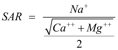
Results and Discussion
Ground water table depths
The water table depths in different locations of the study area are given in Figure 3. It can be seen from the Figure that water table from the ground surface ranged from 6 to 91.5 m. Most of the tube wells were constructed during the period 1970 to 2009. Before seventies, only open wells for domestic water supply and irrigation were in use in the regions with relatively shallow ground water. The shallowest (< 15 m) water table from the ground surface was observed at Sarki Lawaghar, Latambar and Wanki Saraj Khel (W S Khel) and the deepest water table from the ground surface was recorded at Zarin Kala. Few small dams have been constructed in different areas of the valley and the effect of these dams can be seen in different villages as the water table is in rising trend in 35 villages out of 36 (Figure 4). The water level is going down in city of Takht-e-Nasrati. It may be due
to urbanization with excessive withdrawal. The wells showing rising water level trend are mostly in the areas close to Chengoze and Lowaghar dams. It was observed that water table was becoming shallower in the downstream areas in the vicinity of dams, especially in the villages Latambar, Kamala, Aral Banda, Takht-e-Nasrati and Zarki Nasrati.
Ground water table depths in 1983 and 2009
Ground water table depths of few locations found in the study conducted by Water and Power Development Authority (WAPDA) under PAK-Dutch Program for Ground Water Investigation in 1983 were compared with findings of current study (2009). It is clear from the Figure 5 that the water table from the ground surface at Latamber, Warana and Ahamdabad has shown upward trend and increased by about 0.3 m per year. On the other hand, at Jehangari and Zarin Banda, the water table has decreased byabout 0.1 m per year. Although the current study has shown that in most parts of the study area the water table is getting shallower but some parts are showing opposite trends.
Pumps efficiencies, wells discharge and motors power
The total numbers of operational wells were about 650 (including deep tube wells, pressure pumps and shallow open wells equipped with centrifugal pumps). Nearly all tube wells were equipped with 25 HP pumps; the open wells with 5 HP and pressure pumps with 2 HP. The pumps efficiencies of the sampled tube wells ranged from 22 to 73% with an overall average of 42%. The average efficiency of the pump was found lower than recommended value of 75%. This shows that the pumps are being run lower than their desired efficiency and are consuming more electricity and hence have scope for improvement in efficiency. The wells discharges vary from 2 to 14 lit s-1 and the power of the pumping units ranged from 2 to 30 HP.
Increase in tube wells numbers
The number of tube wells pumping ground water has increased with time. Very few tube wells were in use before seventies. But during the last two decades the number of tube wells extracting ground water has increased several folds (Figure 6). In case the installations of tube wells increase with such a rate, it will accelerate the groundwater depletion several folds and without remedial measures the fresh ground water in study area; which is the only available aquifer having a thickness of about 120 ft may not last longer.
Ground water quality
Data collected regarding pH of ground water from different wells located at different villages are shown Figure 7. The pH values ranged from 8.2 to 8.9 and the average value of pH was 8.55. The normal range of pH for irrigation water use was 6.5 to 8.4 and values outside of this range may cause nutritional imbalance for crops and values less than 6.5 may accelerates the corrosion of irrigation system. Water, having pH value higher than 8.5, may have excessive carbonates and bicarbonates concentration (Ayers and Westcot, 1985). Village-wise electrical conductivity (ECw) of the ground water samples are given in Figure 8.
ECw ranges from 0.4-4.7 dS/m. It can be depicted that the ECw of village Warana, Narre Khawar, Surati Kala, Sur Dag, Sharif Wala and Odin Shah was found unsafe for drinking as well as for irrigation purposes. On the basis of ECw, the water quality in rest of the wells was found fit both for drinking and irrigation purposes as per standards of WAPDA (1974).
Water samples of all villages’can be categorized safe for irrigation on the basis of SAR (Figure 9). Sodium is generally found in irrigation water, based on sodium concentration, the water has been divided into four classes: water samples having sodium from 0 to 10 are classed as S1; 10 to 18 as S2; 18 to 26 as S3, and above 26 are classed as S4 (Richards, 1954). The combine effect of ECw and sodium (or SAR) is presented Figure 10, which shows that the values of 21 villages fall in category of C2S1, 6 values in class C3S1, and 4 villages values lies in C4S2 class. Water salinity has different effects on soil and crop yield. Under saline environment the water is held tight to soil particles and less available for plants growth due to osmotic effects. Ayers and Westcot, 1985 reported that if irrigation water has EC equal to 1 dS m-1, about 17 cm of water is available per meter of soil depth, however, when ECw value reaches to 10 dS m-1, nearly 6 cm of water is available per meter depth of soil. Thus, it will increase the number of irrigation to the field in the saline condition.
Conclusions and Recommendations
A significant recharge was observed in the vicinity of Changhooz and Sarki dam. A small rise in water table was also observed in most part of the study area. When compared with the 1983 study conducted under Pak-Dutch Program, it was observed that water table in Latamber, Warana and Ahamdabad areas is increasing at a rate of about 0.3 m annually. However, in Jehangari and Zarin Banda, it is decreasing at about 0.1 m per year. A significant increase in number of tube wells was observed with time. The water quality reveals that pH of the water varies from 8.2-8.9 while ECw ranges from 0.4-4.7 dSm-1. Water qualities of six villages out of 36 were found unsafe for irrigation purposes as per standard recommended by WAPDA, (1974) and Sodium Adsorption Ratio was within safe range. In Richard’s salinity diagram (Figure 10), it was observed that 21 (60%) village waters fall in C2-S1 class indicating medium salinity having low Sodium concentration and may be suitable to salt tolerant crops.
Extensive ground water exploitation in District Karak through large tube well schemes should be avoided due to limited recharge and poor condition of the aquifer. To avoid depletion of the ground water resources, in district Karak, measures must be adopted for recharge of the ground water aquifer through construction of small dams in the catchments of the recharge area. Communities must be educated about the judicious use of limited ground water resources. In areas of such limited ground water resources, use for irrigation should be discouraged. The ground water monitoring program should be established and the quantity and quality of the ground water should be assessed regularly in the valley. Mass awareness campaign should be launched for education of the communities on the availability of ground water resources in the district. Water conservation strategies should be developed at district level. A top priority should be given to construction of water storage reservoirs and recharge structures. A detailed resistivity survey should be conducted to find the recharge of small dams, rate of saline water intrusion into fresh aquifer and to assess the availability and use of ground water resources in the district. In areas showing decline in ground water table, the extraction should be restricted to avoid over exploitation.
Author’s Contributions
Muhammad Jamal Khan: Analysed and interpreted the data and wrote the article
Abdul Malik: Worked on acquisition of data
Muhammad Shahzad Khattak: Asissted in compiling and presenting data
Naveedullah and Naeem Ijaz: Revised the article
Ishaq Ahmad: Helped in drafting the article.
References
Ahmed, U.I., l. Ying, M.K. Bashir, M. Abid, and F. Zulfiqar. 2017. Status and determinants of small farming households’ food security and role of market access in enhancing food security in rural Pakistan. PLoS ONE 12(10).
Asian Development Bank (ADB). 2013. Asian development outlook: Asia’s energy challenge, Mandaluyong City, Philippines.
Awan, U.K., Liaqat, U.W. Choi and M. Ismaeel. 2016. A SWAT modeling approach to assess the impact of climate change on consumptive water use in lower Chenab Canal area of Indus basin. Hydrol. Res. 47: 1025-1037.
Ayers, R.S. and Westcot. D.W. 1985. Water Quality for Agriculture, Irrigation and Drainage Paper No. 29, FAO, Rome.
Government of Pakistan (GOP) (2014–15).Pakistan economic survey. Economic Affairs Division, Pakistan.
Haub, C. and M.M. Kent. 1989. World Population Data Sheet. Population Reference Bureau, Inc., Washington D.C
Hussain, I., Z. Hussain, H. Maqbool., A. Waqar. and M.F. Farhan. 2011. Water balance, supply and demand and irrigation efficiency of Indus Basin. Pak. Econ. Soc. Rev. 49(1):13-38.
Khan, M. and F. Hussain. 2013. Plant life Classification in Summer of Tehsil Takht-i- Nasrati, District Karak, Khyber Pakhtunkhawa, Pakistan. Annual Rev. Res. Biol. 3(3): 176-187.
Usman, M., A. Abbas and Z.A. Saqib. 2016. Conjunctive use of water and its management for enhanced productivity of major crops across tertiary canal irrigation system of Indus Basin in Pakistan. Pak. J. Agri. Sci. 53(1): 257-264.
Qureshi, A. 2009. Managing salinity in the Indus Basin of Pakistan. Int. J. River Basin Manag. 7 (2): 111–117. https://doi.org/10.1080/15715124.2009.9635373
Qureshi, A.S., P.G. Mccornick., A. Sarwar and B.R. Sharma. 2010. Challenges and prospects of sustainable groundwater management in the Indus Basin, Pakistan. Water Resour. Manage. 24:1551. https://doi.org/10.1007/s11269-009-9513-3
Richards, L.A. 1954. Diagnosis and improvement of saline and alkali soils, U.S. Dept. Agri. Hand book, No. 60, pp. 160.
Shah, T. 2007. The Ground water economy of South Asia: An Assessment of Size, Significance and Socio-ecological Impacts. In: M. Giordano, K.G. Villholth (Eds.). The Agricultural Groundwater Revolution: Opportunities and Threats to Development, CABI, Wallingford, UK.
Steenbergen, F.V., and W. Oliemans. 2002. A review of policies in groundwater management in Pakistan 1950–2000. Water Policy. 4:323–344. https://doi.org/10.1016/S1366-7017(02)00006-5
Tabassum, I., F. Rahman and F. Haq. 2014. Dynamics of communal land degradation and its implications in the arid mountains of Pakistan: A Study of District Karak, Khyber Pakhtunkuwa. J. Mt. Sci. 11(2): 485-495. https://doi.org/10.1007/s11629-013-2771-9
United Nation Development Programe (UNDP). 2016. Water Security in Pakistan: Issues and challenge. Development advocate Pakistan. 3(4).
United Nations (UN), Department of Economic and Social Affairs, Population Division. 2017. World Population Prospects: The 2017 Revision, Methodology of the United Nations Population Estimates and Projections, Working Paper No. ESA/P/WP.250. New York: United Nations.
WAPDA. 1974a. Technical Report on Ground Water Resources in Domail Plain, Bannu and Karak District, N.W.F.P. Report No. IV-1.
WAPDA. 1974b. Technical Report on Ground Water Resources in Karak valley, Karak District, N.W.F.P. Report No. IV-2.
World Wide Fund for Nature (WWF) Report. 2012. Development of Integrated River Basin Management (IRBM) for Indus Basin – Challenges and Opportunities.
To share on other social networks, click on any share button. What are these?